of the Appalachian Mountains "Banque de noms de lieux du Québec - Monts McGerrigle". Commission de Toponymie. Retrieved 2016-09-23. "The Gaspé: Oceans...
5 KB (209 words) - 14:25, 4 January 2024

Sainte-Anne-des-Monts is located close to the Chic-Choc Mountains on the south shore of Gulf of St Lawrence. In addition to Sainte-Anne-des-Monts itself, the...
19 KB (987 words) - 18:42, 23 May 2024

roches aux paysages actuels (in French). doi:10.13140/2.1.3712.5441. "Monts McGerrigle". Commission de Toponymie du Québec. Bank of place names in Quebec...
8 KB (630 words) - 21:32, 19 June 2024
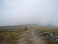
Sainte-Anne-des-Monts, Quebec, Canada in the inland of the Gaspé peninsula. The park contains the highest peak of the Appalachian Mountains in Canada, Mont Jacques-Cartier...
4 KB (374 words) - 15:44, 17 December 2022

exploration. The name appeared on a geological map in 1925. It is part of the McGerrigle chain with Xalibu and Jacques-Cartier. The alpine tundra dominates its...
5 KB (145 words) - 21:21, 16 December 2021
71°06′10″W / 45.2969°N 71.1028°W / 45.2969; -71.1028 (Mont D'Urban) Mont de la Passe McGerrigle Mountains mountain Gaspésie–Îles-de-la-Madeleine, Quebec...
114 KB (82 words) - 13:56, 5 July 2024

characterized by the Chic-Choc and McGerrigle mountain ranges. In this massif, about 1,270 metres (4,170 ft) of altitude, are the Mont Jacques-Cartier which is...
30 KB (3,705 words) - 19:55, 26 January 2024