
 French
 Deutsch
Файл:Macquarie Island map - Mawson.gif – Уикипедия

Размер на този преглед: 454 × 599 пиксела. Други разделителни способности: 182 × 240 пиксела | 364 × 480 пиксела | 640 × 844 пиксела.
Оригинален файл (640 × 844 пиксела, големина на файла: 21 КБ, MIME-тип: image/gif)
| Този файл е от Общомедия и може да се използва от други проекти. Следва информация за файла, достъпна през оригиналната му описателна страница. |
Резюме
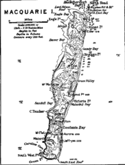
| Описание | Contour map of Macquarie Island. |
| Източник | The Home of the Blizzard - Being the Story of the Australasian Antarctic Expedition, 1911-1914, by Douglas Mawson. Project Gutenberg etext 6137, file txt3.gif. |
| Автор | Mawson, Douglas, 1882-1958 |
| Права (Повторно използване на файла) | Public domain in the US |
Лицензиране
This image or other work is of Australian origin and is now in the public domain because its term of copyright has expired. According to the Australian Copyright Council (ACC), ACC Information Sheet G023v19 (Duration of copyright) (January 2019).1
When using this template, please provide information of where the image was first published and who created it. |  | |||||||||||||||||||
Това произведение е обществено достояние в Съединените американски щати, защото е било публикувано преди 1 януари 1929 година. |
This image or other work is of Australian origin and is now in the public domain because its term of copyright has expired. According to the Australian Copyright Council (ACC), ACC Information Sheet G023v19 (Duration of copyright) (January 2019).1
When using this template, please provide information of where the image was first published and who created it. | | |||||||||||||||||||
First published in Mawson, D. (1914). The Home of the Blizzard.
История на файла
Избирането на дата/час ще покаже как е изглеждал файлът към онзи момент.
| Дата/Час | Миникартинка | Размер | Потребител | Коментар | |
|---|---|---|---|---|---|
| текуща | 14:32, 13 май 2007 | | 640 × 844 (21 КБ) | Avenue | {{Information |Description=Contour map of Macquarie Island. |Source=The Home of the Blizzard - Being the Story of the Australasian Antarctic Expedition, 1911-1914, by Douglas Mawson. [http://www.gutenberg.org/etext/6137 Project Gutenberg etext 6137], file |
Използване на файла
Следната страница използва следния файл:
Глобално използване на файл
Този файл се използва от следните други уикита:
- Употреба в be-tarask.wikipedia.org
- Употреба в fr.wikipedia.org
- Употреба в pl.wikipedia.org
- Употреба в pt.wikipedia.org
- Употреба в uk.wikipedia.org
- Употреба в zh.wikipedia.org