
 French
 Deutsch
Datei:Blue Hills Reservation Parkways.png – Wikipedia

Größe dieser Vorschau: 800 × 446 Pixel. Weitere Auflösungen: 320 × 178 Pixel | 640 × 357 Pixel | 1.024 × 571 Pixel | 1.280 × 714 Pixel | 2.583 × 1.440 Pixel
Originaldatei (2.583 × 1.440 Pixel, Dateigröße: 8,76 MB, MIME-Typ: image/png)
![]()
Diese Datei und die Informationen unter dem roten Trennstrich werden aus dem zentralen Medienarchiv Wikimedia Commons eingebunden.
![]()
| Dieses Bild zeigt ein Objekt, das im National Register of Historic Places der Vereinigten Staaten verzeichnet ist. Die Referenznummer lautet 3000746. |
Beschreibung
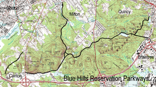
| Beschreibung | English: Map of the Blue Hills Reservation Parkways Braintree, Canton, Milton, and Quincy Massachusetts |
| Datum | |
| Quelle | USGS Topo, additions by User:Jameslwoodward |
| Urheber | Jameslwoodward |
| Objektposition | | Dieses und weitere Bilder auf OpenStreetMap |
|---|
Lizenz
Ich, der Urheberrechtsinhaber dieses Werkes, veröffentliche es hiermit unter der folgenden Lizenz:
 | Es ist erlaubt, die Datei unter den Bedingungen der GNU-Lizenz für freie Dokumentation, Version 1.2 oder einer späteren Version, veröffentlicht von der Free Software Foundation, zu kopieren, zu verbreiten und/oder zu modifizieren; es gibt keine unveränderlichen Abschnitte, keinen vorderen und keinen hinteren Umschlagtext. Der vollständige Text der Lizenz ist im Kapitel GNU-Lizenz für freie Dokumentation verfügbar. |
Diese Datei ist unter den Creative Commons-Lizenzen Namensnennung – Weitergabe unter gleichen Bedingungen 4.0 International, 3.0 nicht portiert, 2.5 Allgemein, 2.0 Allgemein und 1.0 Allgemein lizenziert.
- Dieses Werk darf von dir
- verbreitet werden – vervielfältigt, verbreitet und öffentlich zugänglich gemacht werden
- neu zusammengestellt werden – abgewandelt und bearbeitet werden
- Zu den folgenden Bedingungen:
- Namensnennung – Du musst angemessene Urheber- und Rechteangaben machen, einen Link zur Lizenz beifügen und angeben, ob Änderungen vorgenommen wurden. Diese Angaben dürfen in jeder angemessenen Art und Weise gemacht werden, allerdings nicht so, dass der Eindruck entsteht, der Lizenzgeber unterstütze gerade dich oder deine Nutzung besonders.
- Weitergabe unter gleichen Bedingungen – Wenn du das Material wiedermischst, transformierst oder darauf aufbaust, musst du deine Beiträge unter der gleichen oder einer kompatiblen Lizenz wie das Original verbreiten.
Du darfst es unter einer der obigen Lizenzen deiner Wahl verwenden.
Dateiversionen
Klicke auf einen Zeitpunkt, um diese Version zu laden.
| Version vom | Vorschaubild | Maße | Benutzer | Kommentar | |
|---|---|---|---|---|---|
| aktuell | 19:32, 30. Sep. 2009 | | 2.583 × 1.440 (8,76 MB) | Jameslwoodward | {{Information |Description={{en|1=Map of the Blue Hills Reservation Parkways Braintree, Canton, Milton, and Quincy Massachusetts}} |Source=USGS Topo, additions by User:Jameslwoodward |Author=Jameslwoodward |Date=2009-09-29 |Permiss |
| 19:29, 30. Sep. 2009 |  | 2.583 × 1.440 (8,76 MB) | Jameslwoodward | {{Information |Description={{en|1=Map of the Blue Hills Reservation Parkways Braintree, Canton, Milton, and Quincy Massachusetts}} |Source=USGS Topo, additions by User:Jameslwoodward |Author=Jameslwoodward |Date=2009-09-29 |Permiss | |
| 19:18, 30. Sep. 2009 |  | 2.583 × 1.440 (8,76 MB) | Jameslwoodward | {{Information |Description={{en|1=Map of the Blue Hills Reservation Parkways Braintree, Canton, Milton, and Quincy Massachusetts}} |Source=USGS Topo, additions by User:Jameslwoodward |Author=Jameslwoodward |Date=2009-09-29 |Permiss |
Dateiverwendung
Die folgenden 3 Seiten verwenden diese Datei:
Globale Dateiverwendung
Die nachfolgenden anderen Wikis verwenden diese Datei:
- Verwendung auf en.wikipedia.org
- Verwendung auf www.wikidata.org