
 French
 Deutsch
Datei:Map of Yarralumla in Canberra.gif – Wikipedia
Größe dieser Vorschau: 800 × 542 Pixel. Weitere Auflösungen: 320 × 217 Pixel | 640 × 434 Pixel | 1.024 × 694 Pixel | 1.280 × 867 Pixel | 2.300 × 1.558 Pixel
Originaldatei (2.300 × 1.558 Pixel, Dateigröße: 390 KB, MIME-Typ: image/gif)
![]()
Diese Datei und die Informationen unter dem roten Trennstrich werden aus dem zentralen Medienarchiv Wikimedia Commons eingebunden.
![]()
Beschreibung
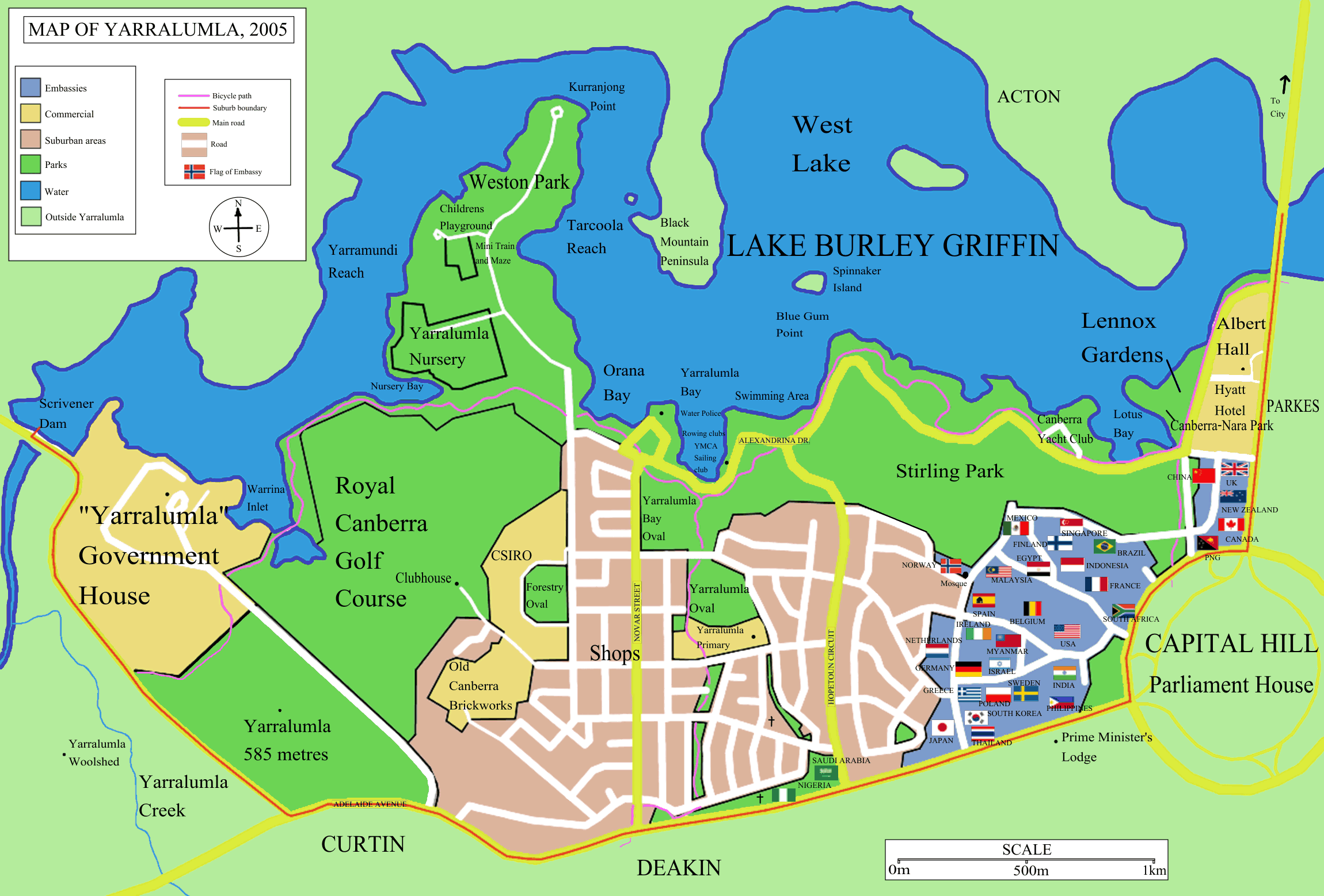
Map of w:Yarralumla, suburb of w:Canberra. Shows the foreign embassies to Australia which are located within the suburb. (others are located in different suburbs). I made the map, based on UBD maps of Canberra, with some additions ---- Astrokey44 05:45, 4 November 2005 (UTC)
Lizenz
 | Es ist erlaubt, die Datei unter den Bedingungen der GNU-Lizenz für freie Dokumentation, Version 1.2 oder einer späteren Version, veröffentlicht von der Free Software Foundation, zu kopieren, zu verbreiten und/oder zu modifizieren; es gibt keine unveränderlichen Abschnitte, keinen vorderen und keinen hinteren Umschlagtext. Der vollständige Text der Lizenz ist im Kapitel GNU-Lizenz für freie Dokumentation verfügbar. |
| Diese Datei ist unter der Creative-Commons-Lizenz „Namensnennung – Weitergabe unter gleichen Bedingungen 3.0 nicht portiert“ lizenziert. | ||
| ||
| Diese Lizenzmarkierung wurde auf Grund der GFDL-Lizenzaktualisierung hinzugefügt. |
Dateiversionen
Klicke auf einen Zeitpunkt, um diese Version zu laden.
| Version vom | Vorschaubild | Maße | Benutzer | Kommentar | |
|---|---|---|---|---|---|
| aktuell | 17:18, 6. Nov. 2005 | | 2.300 × 1.558 (390 KB) | Roke~commonswiki | nigeria, saudi arabia, mosque, took out "mt" - made green |
| 07:04, 5. Nov. 2005 |  | 2.300 × 1.558 (395 KB) | Roke~commonswiki | fixed scale | |
| 05:57, 5. Nov. 2005 |  | 2.300 × 1.558 (419 KB) | Roke~commonswiki | ||
| 05:47, 4. Nov. 2005 |  | 2.000 × 1.370 (221 KB) | Roke~commonswiki | ||
| 05:38, 4. Nov. 2005 |  | 2.000 × 1.370 (230 KB) | Roke~commonswiki | Map of w:Yarralumla, suburb of w:Canberra. Shows foreign embassies to Australia. I made the map, based on UBD map of Canberra. Category: Maps of Canberra Category: Canberra |
Dateiverwendung
Die folgende Seite verwendet diese Datei: