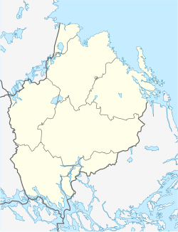
Österbybruk
Österbybruk | |
|---|---|
 Walloon forge in Österbybruk | |
| Coordinates: 60°12′N 17°54′E / 60.200°N 17.900°E | |
| Country | Sweden |
| Province | Uppland |
| County | Uppsala County |
| Municipality | Östhammar Municipality |
| Area | |
• Total | 2.51 km2 (0.97 sq mi) |
| Population (31 December 2020)[2] | |
• Total | 2,375 |
| • Density | 950/km2 (2,500/sq mi) |
| Time zone | UTC+1 (CET) |
| • Summer (DST) | UTC+2 (CEST) |
Österbybruk is a locality situated in Östhammar Municipality, Uppsala County, Sweden with 2,272 inhabitants in 2010.[1]
Ironworks
[edit]The Österby works was one of a number mostly in Roslagen, where there were Walloon forges, producing high quality oregrounds iron for export. Österby's brand mark was OO. All iron was branded with that mark. The Österby ironproducts were highly valued in England for the production of blister steel by the cementation process.
The historical complex of Österbybruk is a "Vallonbruk", a social and economic building complex surrounding a forge. Österbybruk is one of the most beautiful examples of the remains of the presence and input of Walloon immigrants ('valloner') in Sweden in the 17th century. More than 1.200 families emigrated in that era to Sweden, where the expertise of Walloon master blacksmiths was highly sought after. They helped to launch the Swedish iron and metal industry. The number of their descendants is estimated today between 500.000 and 1 million people.[3]
People
[edit]- Karl Kilbom, the leader of the Swedish Communist Party 1924-1929 was born here, and one of the main streets of Österbybruk is named after him today.
Climate
[edit]Österbybruk has a humid continental climate that is quite mild throughout the year, especially considering its northerly latitude.
| Climate data for Österbybruk, 2002-2015 (precipitation 1961-1990) | |||||||||||||
|---|---|---|---|---|---|---|---|---|---|---|---|---|---|
| Month | Jan | Feb | Mar | Apr | May | Jun | Jul | Aug | Sep | Oct | Nov | Dec | Year |
| Record high °C (°F) | 10.0 (50.0) | 11.9 (53.4) | 17.7 (63.9) | 27.4 (81.3) | 28.6 (83.5) | 30.6 (87.1) | 34.4 (93.9) | 32.8 (91.0) | 27.6 (81.7) | 20.6 (69.1) | 14.4 (57.9) | 12.6 (54.7) | 34.4 (93.9) |
| Mean daily maximum °C (°F) | −0.5 (31.1) | 0.2 (32.4) | 4.4 (39.9) | 10.9 (51.6) | 15.9 (60.6) | 19.7 (67.5) | 23.0 (73.4) | 21.6 (70.9) | 16.6 (61.9) | 9.4 (48.9) | 4.4 (39.9) | 1.1 (34.0) | 10.5 (50.9) |
| Daily mean °C (°F) | −3.5 (25.7) | −3.1 (26.4) | −0.1 (31.8) | 5.3 (41.5) | 10.0 (50.0) | 14.4 (57.9) | 17.3 (63.1) | 16.0 (60.8) | 11.5 (52.7) | 5.7 (42.3) | 1.9 (35.4) | −1.7 (28.9) | 6.1 (43.0) |
| Mean daily minimum °C (°F) | −6.6 (20.1) | −6.5 (20.3) | −4.6 (23.7) | −0.2 (31.6) | 4.2 (39.6) | 8.1 (46.6) | 11.6 (52.9) | 10.5 (50.9) | 6.4 (43.5) | 2.0 (35.6) | −0.6 (30.9) | −4.4 (24.1) | 1.6 (34.9) |
| Record low °C (°F) | −34.0 (−29.2) | −30.4 (−22.7) | −27.3 (−17.1) | −13.8 (7.2) | −5.6 (21.9) | −2.0 (28.4) | 1.0 (33.8) | −1.0 (30.2) | −4.7 (23.5) | −15.6 (3.9) | −20.9 (−5.6) | −32.4 (−26.3) | −34.0 (−29.2) |
| Average precipitation mm (inches) | 46.5 (1.83) | 32.5 (1.28) | 33.2 (1.31) | 35.0 (1.38) | 31.7 (1.25) | 38.8 (1.53) | 74.6 (2.94) | 73.8 (2.91) | 58.9 (2.32) | 55.1 (2.17) | 62.0 (2.44) | 51.6 (2.03) | 593.6 (23.37) |
| Source 1: SMHI[4] | |||||||||||||
| Source 2: SMHI Monthly Data 2002-2015[5] | |||||||||||||
References
[edit]- ^ a b "Tätorternas landareal, folkmängd och invånare per km2 2005 och 2010" (in Swedish). Statistics Sweden. 14 December 2011. Archived from the original on 27 January 2012. Retrieved 10 January 2012.
- ^ "Statistiska tätorter 2020, befolkning, landareal, befolkningstäthet". Statistics Sweden. 31 December 2020. Retrieved 3 June 2024.
- ^ "Prize for Belgian heritage abroad | Focus on Belgium". focusonbelgium.be. Retrieved 2016-03-20.
- ^ "Precipitation Normals 1961-1990" (in Swedish). Swedish Metereological and Hydrological Institute (Films kyrkby code 10 713).
- ^ "Monthly and Yearly Statistics" (in Swedish). SMHI. March 12, 2016.


 French
 Deutsch
