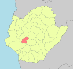
Anding District, Tainan
23°5′57.53″N 120°13′37.79″E / 23.0993139°N 120.2271639°E
Anding 安定區 | |
|---|---|
| Anding District | |
 Sesame fields in Anding | |
 | |
| Coordinates: 23°5′57.53″N 120°13′37.79″E / 23.0993139°N 120.2271639°E | |
| Country | |
| Special municipality | Tainan |
| Area | |
| • Total | 12.0734 sq mi (31.27 km2) |
| Elevation | 16 ft (5 m) |
| Population (January 2023) | |
| • Total | 29,914 |
| • Density | 2,483/sq mi (959/km2) |
| Time zone | UTC+8 (+8) |
| Website | web |

Anding District (Chinese: 安定區; pinyin: Āndìng Qū; Wade–Giles: An1-ting4 Ch'ü1; Pe̍h-ōe-jī: An-tēng khu) is a rural district of about 29,914 residents in Tainan, Taiwan, with an area of 31.27 square kilometers, or 12.0734 square miles. It is the 17th most populous district in Tainan, with a population density of 959 people per square kilometer, or 2,483 people per square mile.
History
[edit]During the Dutch colonial era the area was known as Bakloan[1] or Baccloan,[2][failed verification] with a rarer spelling of Baccaluang. The village was one of four main aboriginal villages near the Dutch base of Tayouan, with around 1,500 inhabitants.[3] It was located about 12 kilometres (7.5 mi) northeast of the Dutch base at Fort Zeelandia.
Republic of China
[edit]After the handover of Taiwan from Japan to the Republic of China in 1945, Anding was organized as a rural township of Tainan County. On 25 December 2010, Tainan County was merged with Tainan City and Anding was upgraded to a district of the city.
Administrative divisions
[edit]Anding district consists of Sulin, Sucuo, Anding, Baoxi, Anjia, Gangwei, Nanan, Guanliao, Zhongrong, Gangkou, Hailiao, Datong, Liujia, Gangnan, Zhongsa and Xinji Borough.[4]
Tourist attractions
[edit]References
[edit]- ^ Campbell (1903), p. 538.
- ^ 臺南市政府區公所-安定區. tainan.gov.tw (in Chinese). Archived from the original on 2013-10-29. Retrieved 2014-05-25.
- ^ Andrade, Tonio (2005). "Chapter 3: Pax Hollandica". How Taiwan Became Chinese: Dutch, Spanish, and Han Colonization in the Seventeenth Century. Columbia University Press. § 3.
- ^ "Location of Boroughs". Anding District Office, Tainan City. 2010-12-25. Archived from the original on 2017-04-29. Retrieved 23 April 2018.
- ^ "Anding Township". Tainan County Government. 2009-10-26. Archived from the original on 2014-02-21. Retrieved 2014-05-25.
Cited works
[edit]- Campbell, William (1903). "Explanatory Notes". Formosa Under the Dutch: Described from Contemporary Records, with Explanatory Notes and A Bibliography of the Island. London: Kegan Paul. LCCN 04007338.
External links
[edit]


 French
 Deutsch