Bačko Dobro Polje
Bačko Dobro Polje Бачко Добро Поље (Serbian) | |
|---|---|
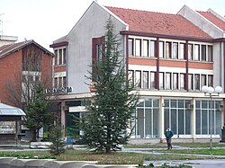
 Building in centre of the village. | |
| Coordinates: 45°30′N 19°41′E / 45.500°N 19.683°E | |
| Country | |
| Province | |
| Region | Bačka (Podunavlje) |
| District | South Bačka |
| Municipality | |
| Population (2002) | |
| • Total | 3,929 |
| Time zone | UTC+1 (CET) |
| • Summer (DST) | UTC+2 (CEST) |

Bačko Dobro Polje (Serbian Cyrillic: Бачко Добро Поље; Hungarian: Kiskér) is a village in Serbia, in the Autonomous Province of Vojvodina. It is located in the South Bačka District. Administratively it belongs to the municipality of Vrbas. The village population numbering 3,929 people (2002 census) has a Serb ethnic majority. It was mostly constructed by settlers from Montenegro in the early 1950s.
Ethnic groups
[edit]1971
[edit]According to the 1971 census, ethnic Montenegrins comprised 55.39% of population of the village.
2002
[edit]In 2002 census, 2,246 (57.17%) inhabitants of the village declared themselves as Serbs and 1,500 (38.18%) as Montenegrins.
Historical population
[edit]- 1961: 3,922
- 1971: 3,622
- 1981: 3,768
- 1991: 3,940
Sport
[edit]Sutjeska is a football club in Bačko Dobro Polje.
According to their Montenegrin roots, they named the football club after the football club from the Montenegrin town of Nikšić. "FK Sutjeska" is a member of "Druga Vojvođanska liga Zapad" (Second Vojvodinian League West) and is currently occupying a low position in the league. However, it had some decent moments in the past and played important role in the Serbian football scene.
See also
[edit]References
[edit]- Republika Srbija, Republički zavod za statistiku, Popis stanovništva, domaćinstava i stanova u 2002., Stanovništvo - nacionalna ili etnička pripadnost, podaci po naseljima 1, Beograd (February 2003).
- Dr Branislav Bukurov, Bačka, Banat i Srem, Novi Sad (1978).
- Slobodan Ćurčić, Broj stanovnika Vojvodine, Novi Sad, 1996.
45°30′N 19°41′E / 45.500°N 19.683°E


 French
 Deutsch

