Blackwood, New Jersey
Blackwood, New Jersey | |
|---|---|
 Aerial view of the main campus of Camden County College in Blackwood | |
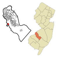
 Map of Blackwood CDP in Camden County. Inset: Location of Camden County within New Jersey. | |
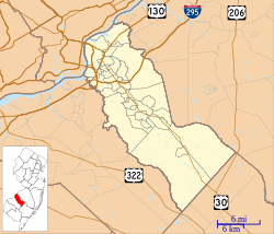
Location in Camden County Location in New Jersey | |
| Coordinates: 39°47′57″N 75°03′47″W / 39.799065°N 75.063111°W[1][2] | |
| Country | |
| State | |
| County | Camden |
| Township | Gloucester |
| Area | |
| • Total | 1.23 sq mi (3.20 km2) |
| • Land | 1.22 sq mi (3.16 km2) |
| • Water | 0.01 sq mi (0.04 km2) 0.72% |
| Elevation | 46 ft (14 m) |
| Population | |
| • Total | 4,622 |
| • Density | 3,788.52/sq mi (1,462.76/km2) |
| Time zone | UTC−05:00 (Eastern (EST)) |
| • Summer (DST) | UTC−04:00 (Eastern (EDT)) |
| ZIP Code | 08012[6] |
| Area code | 856 |
| FIPS code | 34-06040[1][7][8] |
| GNIS feature ID | 02389213[1][9] |
| "At Blackwoodtown, N.J.", 1851, courtesy of Library of Congress[10] | |
Blackwood is an unincorporated community and census-designated place (CDP)[11] located within Gloucester Township, in Camden County, in the U.S. state of New Jersey.[12][13][14] As of the 2010 United States census, Blackwood's population was 4,545.[15] It is located 10 miles (16 km) from the city of Camden and 14.6 miles (23.5 km) away from Philadelphia in the South Jersey region of the state.
Blackwood is the home of the main campus of Camden County College.[16] Blackwood is home to Camden County College's radio station WDBK, which has been broadcasting on 91.5 FM since 1977.[17]
History
[edit]
Blackwood, originally known as Blackwoodtown, was settled about 1750 by John Blackwood in an area then known as "head of Timber Creek." Blackwood was a fuller who immigrated from Scotland and established mills in Blackwoodtown.[18] The area was a crossroads village along the Black Horse Pike well into the nineteenth century, that served as a local government and transportation center by the 1830s, when Uriah Norcross established a stage coach line between Camden and Woodbury with a stop at a tavern in Blackwoodtown. The arrival of the Camden County Railroad in 1891 led to further development.[19][20]
Blackwood Lake operated as a summer resort from 1891 until 1932.[21]
Geography
[edit]According to the U.S. Census Bureau, Blackwood had a total area of 1.235 square miles (3.20 km2), including 1.226 square miles (3.18 km2) of land and 0.009 square miles (0.023 km2) of water (0.72%).[1][2] Bodies of water include Blackwood Lake and Farrows Run stream.
Parks and recreation
[edit]- Gloucester Township Health and Fitness Trail, formerly known as the Blackwood Railroad Trail[22][23]
- Kiwanis's Baseball Fields (Marshall & Railroad Ave)[23][24]
- Al Raw's Field (Lincoln Drive)[23][25]
- Harwan Park (Black Horse Pike)[23]
- State Street Park[23]
Demographics
[edit]| Census | Pop. | Note | %± |
|---|---|---|---|
| 1980 | 5,219 | — | |
| 1990 | 5,120 | −1.9% | |
| 2000 | 4,692 | −8.4% | |
| 2010 | 4,545 | −3.1% | |
| 2020 | 4,622 | 1.7% | |
| Population sources: 1980[26] 1990-2010[14] 2000[27] 2010[15] 2020[5] | |||
2010 census
[edit]The 2010 United States census counted 4,545 people, 1,687 households, and 1,210 families in the CDP. The population density was 3,706.4 people per square mile (1,431.0 people/km2). There were 1,800 housing units at an average density of 1,467.9 units per square mile (566.8 units/km2). The racial makeup was 88.71% (4,032) White, 5.21% (237) Black or African American, 0.04% (2) Native American, 2.53% (115) Asian, 0.00% (0) Pacific Islander, 1.63% (74) from other races, and 1.87% (85) from two or more races. Hispanic or Latino of any race were 5.94% (270) of the population.[15]
Of the 1,687 households, 29.8% had children under the age of 18; 52.2% were married couples living together; 13.2% had a female householder with no husband present and 28.3% were non-families. Of all households, 23.8% were made up of individuals and 9.7% had someone living alone who was 65 years of age or older. The average household size was 2.69 and the average family size was 3.19.[15]
22.4% of the population were under the age of 18, 8.5% from 18 to 24, 26.8% from 25 to 44, 27.8% from 45 to 64, and 14.4% who were 65 years of age or older. The median age was 40.2 years. For every 100 females, the population had 98.6 males. For every 100 females ages 18 and older there were 95.1 males.[15]
2000 census
[edit]As of the 2000 United States Census[7] there were 4,692 people, 1,721 households, and 1,261 families residing in the section. The population density was 1,461.0 people/km2 (3,784 people/sq mi). There were 1,840 housing units at an average density of 572.9 units/km2 (1,484 units/sq mi). The racial makeup of the section was 91.30% White, 3.94% African American, 0.11% Native American, 2.11% Asian, 0.06% Pacific Islander, 1.19% from other races, and 1.28% from two or more races. Hispanic or Latino of any race were 3.15% of the population.[27]
There were 1,721 households, out of which 32.4% had children under the age of 18 living with them, 55.8% were married couples living together, 12.0% had a female householder with no husband present, and 26.7% were non-families. 22.5% of all households were made up of individuals, and 10.1% had someone living alone who was 65 years of age or older. The average household size was 2.68 and the average family size was 3.16.[27]
In the section the population was spread out, with 24.1% under the age of 18, 7.7% from 18 to 24, 30.3% from 25 to 44, 22.1% from 45 to 64, and 15.9% who were 65 years of age or older. The median age was 38 years. For every 100 females, there were 98.7 males. For every 100 females age 18 and over, there were 97.7 males.[27]
The median income for a household in the section was $49,707, and the median income for a family was $60,136. Males had a median income of $41,274 versus $30,677 for females. The per capita income for the section was $21,815. About 0.9% of families and 4.0% of the population were below the poverty line, including 0.6% of those under age 18 and 6.0% of those age 65 or over.[27]
Historic district
[edit]Blackwood Historic District | |
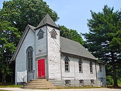
 Blackwood First Methodist Episcopal Church | |
| Location | Black Horse Pike, Baptist Lane, Church and Elm streets, Central and East Railroad avenues |
|---|---|
| Area | 42 acres (17 ha) |
| Architectural style | Greek Revival, Queen Anne |
| NRHP reference No. | 89000996[28] |
| NJRHP No. | 956[29] |
| Significant dates | |
| Added to NRHP | July 27, 1989 |
| Designated NJRHP | June 20, 1989 |
The Blackwood Historic District is a 42-acre (17 ha) national historic district along the Black Horse Pike, Baptist Lane, Church and Elm streets, Central and East Railroad avenues in the community. It was added to the National Register of Historic Places on July 27, 1989, for its significance in commerce and community development. The district includes 87 contributing buildings, 3 contributing structures, and 3 contributing sites. The Blackwood First Methodist Episcopal Church was built in 1856 with Greek Revival/Italianate style.[30]
Education
[edit]Public schools, that are part of the Gloucester Township Public Schools district, include Blackwood Elementary School,[31] Gloucester Township Elementary School[32] as well as Charles W. Lewis Middle School[33] Highland Regional High School is part of the Black Horse Pike Regional School District.
The Kingdom Charter School of Leadership is a charter school that serves students in Kindergarten through sixth grade residing in Gloucester Township, who are accepted by lottery on a space-available basis.[34]
Our Lady of Hope Regional School is a Roman Catholic elementary school that operates under the auspices of the Roman Catholic Diocese of Camden.[35] Our Lady of Hope Regional School was renamed following the 2008 merger of St. Jude's Regional School with St. Agnes School.[36]
Higher education in Blackwood includes Pennco Tech and Camden County College.
Notable people
[edit]People who were born in, residents of, or otherwise closely associated with Blackwood include:
- Jersey Bakley (1864–1915) was a Major League Baseball pitcher who was 19 years old when he broke into the big leagues in 1883 with the Philadelphia Athletics.[37]
- Nick Comoroto (born 1991) professional wrestler known for his appearances with the professional wrestling promotions WWE and All Elite Wrestling.[38]
- Mike Daniels (born 1989), defensive end for the Cincinnati Bengals.[39]
- John A. Dramesi (1933–2017), prisoner of war who had been held by the Viet Cong in the Hanoi Hilton.[40]
- David R. Mayer (born 1967), who represented the 4th Legislative District in the New Jersey General Assembly from 2002 to 2008 and served on the Gloucester Township Council from 2002 to 2003 and as mayor of Gloucester Township.[41]
- Erik Menendez (born 1970), convicted murderer.[42]
- Joseph Menna (born 1970), sculptor.[43]
- Gabriela Mosquera (born 1977), politician, who has served in the New Jersey General Assembly since 2012, where she represents the 4th Legislative District.[44]
- Billy Paul (1934–2016), Grammy Award-winning soul singer.[45]
- Joe Vitt (born 1954), interim head coach of the New Orleans Saints.[46]
References
[edit]- ^ a b c d Gazetteer of New Jersey Places, United States Census Bureau. Accessed July 21, 2016.
- ^ a b US Gazetteer files: 2010, 2000, and 1990, United States Census Bureau. Accessed September 4, 2014.
- ^ "ArcGIS REST Services Directory". United States Census Bureau. Retrieved October 11, 2022.
- ^ U.S. Geological Survey Geographic Names Information System: Blackwood Census Designated Place, Geographic Names Information System. Accessed October 15, 2012.
- ^ a b Census Data Explorer: Blackwood CDP, New Jersey, United States Census Bureau. Accessed June 15, 2023.
- ^ Look Up a ZIP Code for Blackwood, NJ, United States Postal Service. Accessed October 15, 2012.
- ^ a b U.S. Census website, United States Census Bureau. Accessed September 4, 2014.
- ^ Geographic codes for New Jersey, Missouri Census Data Center. Accessed June 9, 2023.
- ^ US Board on Geographic Names, United States Geological Survey. Accessed September 4, 2014.
- ^ At Blackwoodtown, N.J., Library of Congress
- ^ State of New Jersey Census Designated Places - BVP20 - Data as of January 1, 2020, United States Census Bureau. Accessed December 1, 2022.
- ^ GCT-PH1 - Population, Housing Units, Area, and Density: 2010 - County – County Subdivision and Place from the 2010 Census Summary File 1 for Camden County, New Jersey Archived 2020-02-12 at archive.today, United States Census Bureau. Accessed June 19, 2013.
- ^ 2006-2010 American Community Survey Geography for New Jersey, United States Census Bureau. Accessed June 19, 2013.
- ^ a b New Jersey: 2010 - Population and Housing Unit Counts - 2010 Census of Population and Housing (CPH-2-32), United States Census Bureau, p. III-5, August 2012. Accessed June 19, 2013.
- ^ a b c d e DP-1 - Profile of General Population and Housing Characteristics: 2010 Demographic Profile Data for Blackwood CDP, New Jersey Archived February 12, 2020, at archive.today, United States Census Bureau. Accessed October 15, 2012.
- ^ Camden County College, Camden County College. Accessed October 15, 2012. "Camden County College is one of the largest, most comprehensive community colleges in New Jersey and the surrounding region and is a vital resource for transfer education, workforce training and cultural event. Its three distinct campuses in Blackwood, Camden and Cherry Hill – along with its satellite locations in Lakeland, Sicklerville and elsewhere throughout the County – share the common mission of providing accessible, affordable higher education and occupational study to all who can benefit."
- ^ WDBK Radio, Camden County College. Accessed March 22, 2023. "WDBK is the radio voice of Camden County College and has been serving Camden County College and Camden County since 1977. WDBK is a 100-watt, non-commercial radio station broadcasting 24/7 from our studios on the Blackwood campus at 91.5 FM."
- ^ The book of John Howell & his descendants, by Frances Howell
- ^ New Jersey Postal History Society
- ^ Blackwood Historic District, Living Places
- ^ "Gloucester Township: A history with hosiery" Archived May 29, 2014, at archive.today, Courier-Post, October 19, 2006.
- ^ Gloucester Township Health and Fitness Trail (aka Blackwood Railroad Trail), Trail Link
- ^ a b c d e Parks & Playgrounds, Gloucester Township Archived 2014-04-17 at the Wayback Machine
- ^ Field Directions: BKLL Fields Archived March 22, 2015, at the Wayback Machine, Blackwood Kiwanis Little League
- ^ Field Directions: Al Raws Field Archived January 13, 2016, at the Wayback Machine, Blackwood Kiwanis Little League
- ^ Staff. 1980 Census of Population: Number of Inhabitants United States Summary, p. 1-141. United States Census Bureau, June 1983. Accessed June 19, 2013.
- ^ a b c d e DP-1 - Profile of General Demographic Characteristics: 2000 from the Census 2000 Summary File 1 (SF 1) 100-Percent Data for Blackwood CDP, New Jersey Archived 2020-02-12 at archive.today, United States Census Bureau. Accessed October 15, 2012.
- ^ "National Register Information System – (#89000996)". National Register of Historic Places. National Park Service. November 2, 2013.
- ^ "New Jersey and National Registers of Historic Places – Camden County" (PDF). New Jersey Department of Environmental Protection - Historic Preservation Office. September 28, 2021. p. 8.
- ^ Beneson, Carol A. (September 1987). "National Register of Historic Places Inventory/Nomination: Blackwood Historic District". National Park Service. With accompanying 14 photos
- ^ Blackwood Elementary School Archived 2013-04-14 at archive.today
- ^ Gloucester Township Elementary School Archived 2013-04-14 at archive.today
- ^ Charles W. Lewis Middle School Archived 2013-04-14 at archive.today.
- ^ Enrollment Archived 2014-07-23 at the Wayback Machine, The Kingdom Charter School of Leadership. Accessed March 19, 2014.
- ^ Schools, South Jersey Catholic Schools. Accessed February 20, 2023.
- ^ History, Our Lady of Hope Regional School. Accessed February 20, 2023. "Our Lady of Hope Regional School began in 2008 and is the result of a very successful merger of St. Agnes School and St. Jude's Regional School in Blackwood."
- ^ Jersey Bakley, Baseball-Reference.com. Accessed March 19, 2014.
- ^ Flowers, Matt. "South Jersey pro wrestling school expands", NJ Advance Media for NJ.com, October 26, 2015. Accessed January 21, 2021. "Through pro wrestling, Comoroto took an interest in amateur wrestling. The Blackwood native wrestled for Gloucester Catholic High School as a heavyweight in 2009 and for Gloucester County College until 2011, when he decided to pursue pro wrestling."
- ^ Hodkiewicz, Weston. "Nonstop motor powers undersized Mike Daniels", Green Bay Press-Gazette, January 3, 2015. Accessed June 3, 2015. "Mike Daniels wasn't always built like this. Before he was 6 feet tall and 305 pounds, the Green Bay Packers defensive lineman was a small and somewhat scrawny kid growing up in Blackwood, N.J."
- ^ Sipress, Alan. "Each Party Sees Chance To Seize Florio's Seat", The Philadelphia Inquirer, May 30, 1990. Accessed July 20, 2011. "Also seeking the Democratic nomination is John A. Dramesi, 57, of Blackwood. A former prisoner of war in Vietnam, Dramesi said he was asked to run by senior citizens and fellow veterans."
- ^ Assembly Member David R. Mayer, Project Vote Smart. Accessed August 8, 2007.
- ^ Erik Menendez, Biography.com. Accessed August 7, 2016.
- ^ Mucha, Peter. "Carving heroes and villains from virtual clay; Joseph Menna has worked on everything from Jefferson to Batman to the world's biggest statue.", The Philadelphia Inquirer, March 18, 2014. Accessed April 25, 2016. "So it's not surprising to hear Menna say his enthusiasm for art grew from his love of comic books, sci-fi and fantasy while growing up in Blackwood, Camden County, where he graduated from Highland Regional High School."
- ^ Osborne, James. "Appeals court says Gabriela Mosquera can take her Assembly seat after all", The Philadelphia Inquirer, January 10, 2012. Accessed April 25, 2016. "Mosquera's residency came into question last month when Republican Shelley Lovett, who lost to Mosquera in November, filed a lawsuit contending that her opponent had moved to Gloucester Township's Blackwood section in December 2010."
- ^ Chang, David. "Philly Soul Singer Billy Paul Dies at 81: Manager; Billy Paul died at his home Sunday after being hospitalized a week earlier following a cancer diagnosis, according to his manager.", WCAU, April 24, 2016. Accessed April 25, 2016. "Philadelphia soul singer Billy Paul died at the age of 81 Sunday morning, according to his manager... He died Sunday at his home in Blackwood, New Jersey, according to Gay."
- ^ Staff. "Some background on Joe Vitt, interim coach of the New Orleans Saints", The Times-Picayune, April 12, 2012. Accessed November 20, 2012. "Vitt, 57, was born in Syracuse, N.Y., and grew up in Blackwood, N.J."


 French
 Deutsch


