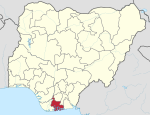
Eleme, Nigeria
This article possibly contains original research. (May 2020) |
Eleme | |
|---|---|
| Coordinates: 4°47′15″N 7°8′37″E / 4.78750°N 7.14361°E | |
| Country | Nigeria |
| State | Rivers State |
| Date created | 1996 |
| Seat | Ogale |
| Government | |
| • Local Government Chairman | Obarilomate Ollor (PDP) |
| • Deputy Local Government Chairman | Virtue Ekee (PDP) |
| • Local Government Council | Ward 1: Victor Daddy Chickere (PDP) Ward 2: Jerry Nwolu Ejor (PDP) Ward 3: Josephine Obari (PDP) Ward 4: Patience Dabor (PDP) Ward 5: Freedom Lekwa (PDP) Ward 6: Dominic Okolah Ollor (PDP) Ward 7: Roberts Ogosu (PDP) Ward 8: Isaac Obele-Chu (PDP) Ward 9: Victor Goka (PDP) Ward 10: Jima Daniel Chumu (PDP) |
| Area | |
| • Total | 53 sq mi (138 km2) |
| Population (2006) | |
| • Total | 190,884 |
| Time zone | UTC+1 (WAT) |
 | |
Eleme is a local government area in Rivers State, Nigeria.[1] It is part of the Port Harcourt metropolitan city.
Eleme has its headquarters in the town of Ogale.[citation needed] It covers an area of 138 km2 and at the 2006 Census had a population of 190,884.[2] The Eleme people are Eleme's main indigenous ethnic group.[3] Eleme LGA has two districts- Nchia and Odido and both administered under the Crown of the Oneh Eh Eleme (King Of Eleme.)[4]
As explained in a book edited by Imelda Icheji Lawrence Udoh and others, the Eleme language, of the Cross-River branch of the larger Niger-Congo language family,[5] is the main spoken language.[6]
Eleme has two of Nigeria's four, as of 2005, petroleum refineries and one of Nigeria's busiest seaport and the largest seaport in West Africa located at Onne, a famous town with numerous industries.[7]
Climate/Geography
[edit]Eleme LGA is made up of numerous rivers and tributaries and has a total size of 138 square kilometers. The local government region experiences 3,250 mm of precipitation annually, with an average temperature of 25 degrees Celsius.[8][9]
Towns and villages in Eleme Local government
[edit]Eleme has ten major towns or principalities which they refer to as The Ten Kingdoms. Each of these towns has numerous clans, subclans and villages headed by a Paramount Ruler popularly known as Oneh Eh-Eta. Under it you have the traditional rulers and the chiefs whose affairs is to oversee smaller units of the traditionals. The ten major towns includes:
- Agbonchia
- Akpajo
- Alesa
- Aleto
- Alode
- Ebubu
- Ekporo
- Eteo
- Ogale
- Onne
References
[edit]- ^ Environment, U. N. (2017-09-21). "About Ogoniland". UNEP - UN Environment Programme. Retrieved 2023-04-28.
- ^ "An Assessment of the Socio-economic Effects ofLand Use Trends and Population Growth in Eleme, Rivers State, Nigeria" (PDF). International Journal of Scientific & Engineering Research. 11.
- ^ "Map - Eleme - MAP[N]ALL.COM". www.mapnall.org. Retrieved 2021-09-18.
- ^ Nlebem, Anthony (2019-07-21). "How Wike moved fast to avert bloodshed in selection of new Eleme monarch". Businessday NG. Retrieved 2024-03-12.
- ^ Anderson, Gregory D. S. (2006) "Appendix: Classification of Languages Used in Database for Study" Auxiliary verb constructions Oxford University Press, Oxford, England, page 400, ISBN 0-19-928031-2
- ^ Udoh, Imelda Icheji Lawrence (editor) (2003) The languages of the South-South zone of Nigeria: a geo-political profile Concept Publications, Lagos, Nigeria, pages 85, 87, ISBN 978-8065-27-9
- ^ Udogu, Emmanuel Ike (2005) Nigeria in the twenty-first century: strategies for political stability and peaceful coexistence Africa World Press, Trenton, New Jersey, page 72, ISBN 1-59221-319-7
- ^ "Eleme Local Government Area". www.manpower.com.ng. Retrieved 2024-08-10.
- ^ "Eleme, Nigeria Weather Conditions | Weather Underground". www.wunderground.com. Retrieved 2024-08-10.


 French
 Deutsch

