Eskişehir
Eskişehir | |
|---|---|
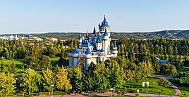
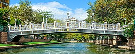
Clockwise from top: Eskişehir Fairy Tale Castle in Sazova Park, Lion Statue in Eskişehir, Porsuk River, Porsuk Bridge, Eskişehir Tram, Eskişehir Municipality | |
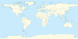
| Coordinates: 39°47′N 30°31′E / 39.783°N 30.517°E | |
| Country | |
| Region | Central Anatolia |
| Province | Eskişehir |
| Government | |
| • Metropolitan Mayor | Ayşe Ünlüce (CHP) |
| Area | |
| • Metropolitan municipality | 2,678.00 km2 (1,033.98 sq mi) |
| Elevation | 788 m (2,585 ft) |
| Population (2022)[1] | |
| • Metropolitan municipality | 789,023 |
| • Density | 335/km2 (868/sq mi) |
| • Urban | 820,568 |
| • Metro | 848,002 |
| GDP | |
| • Metropolitan municipality | TRY 81.527 billion US$ 9.078 billion (2021) |
| • Per capita | TRY 91,234 US$ 10,158 (2021) |
| Time zone | UTC+3 (TRT) |
| Postal code | 26 xxx |
| Area code | (+90) 222 |
| Registration plate | 26 |
| Website | www.eskisehir-bld.gov.tr |
Eskişehir (US: /ˌɛskɪʃəˈhɪər/ ES-kish-ə-HEER,[3][4] Turkish: [esˈciʃehiɾ]; from eski 'old' and şehir 'city')[5] is a city in northwestern Turkey and the capital of the Eskişehir Province. The urban population of the city is 898,369, with a metropolitan population of 797,708.[1] The city is located on the banks of the Porsuk River, 792 m above sea level, where it overlooks the fertile Phrygian Valley. In the nearby hills one can find hot springs. The city is 233 km (145 mi) to the west of Ankara, 330 km (205 mi) to the southeast of Istanbul and 78 km (48 mi) to the northeast of Kütahya. It is located in the vicinity of the ancient city of Dorylaeum.[6] Known as a university town; Eskişehir Technical University, Eskişehir Osmangazi University, and Anadolu University are based in Eskişehir. The province covers an area of 2,678 km2 (1,034 sq mi).[7]
Etymology
[edit]The name Eskişehir can be literally translated as 'Old City' in Turkish.[5] The name has been documented in Ottoman records since the late 15th century.[8]
History
[edit]

The city was founded by the Phrygians in at least 1000 BC, although it has been estimated to be older than 4000 years old. The current city lies about a mile from the ancient Phrygian city of Dorylaeum.[9] Many Phrygian artifacts and sculptures can still be found in the city's archeological museum. There is also a museum of meerschaum stone, whose production remains still notable, used to make high quality meerschaum pipes. In the fourth century AD the city moved about ten km northeast, from Karacahisar to Şehirhöyük. The region was originally inhabited by Hittites.
Many ancient geographers described the city as one of the most beautiful in Anatolia.[citation needed]
As with many towns in Anatolia, Christianity arrived after Constantine the Great legalized the religion in the Roman Empire. Beginning in the 4th century, records exist of bishops holding office in Eskişehir. The city was known as Dorylaeum (Δορύλαιον) in Greek in that period. One of these bishops, Eusebius, was heavily involved in shaping the evolving dogma of the church.
It was called Sultanönü during the Seljuk period.[10] In 1097 it was the site of a battle of the First Crusade in which the Crusaders defeated the Seljuk Turkish sultan Kilij Arslan I; the town later fell to the Turks in 1176, or the 13th century.[9] From 1867 until 1922, Eskişehir was part of Hüdavendigâr vilayet. In 1921, it was captured by the invading Greek Army.Eskisehir holds the title of Cultural Capital of the Turkish World and UNESCO Capital of Intangible Cultural Heritage in 2013.
Geography
[edit]The city of Eskişehir is sited on the banks of Porsuk River, which flows into the Sakarya River. Porsuk Dam, located near the Eskişehir-Kütahya border controls the flow of the water in the river.
Climate
[edit]Eskişehir has a cold semi-arid climate (BSk) under the Köppen climate classification, and a temperate continental climate (Dc) under the Trewartha climate classification.[12][13] The city features cold, snowy winters and warm, dry summers. Rainfall occurs mostly during the spring and autumn. Due to Eskişehir's high altitude and its dry summers, nightly temperatures in the summer months are cool. Precipitation levels are low, but precipitation can be observed throughout the year.
| Climate data for Eskişehir (1991–2020, extremes 1928–2023) | |||||||||||||
|---|---|---|---|---|---|---|---|---|---|---|---|---|---|
| Month | Jan | Feb | Mar | Apr | May | Jun | Jul | Aug | Sep | Oct | Nov | Dec | Year |
| Record high °C (°F) | 20.3 (68.5) | 21.8 (71.2) | 28.1 (82.6) | 31.1 (88.0) | 35.0 (95.0) | 36.8 (98.2) | 40.6 (105.1) | 41.6 (106.9) | 38.4 (101.1) | 34.2 (93.6) | 27.1 (80.8) | 21.4 (70.5) | 41.6 (106.9) |
| Mean daily maximum °C (°F) | 3.9 (39.0) | 6.8 (44.2) | 12.1 (53.8) | 17.0 (62.6) | 22.2 (72.0) | 26.5 (79.7) | 29.8 (85.6) | 29.9 (85.8) | 26.1 (79.0) | 20.2 (68.4) | 12.6 (54.7) | 6.1 (43.0) | 17.8 (64.0) |
| Daily mean °C (°F) | −0.1 (31.8) | 1.5 (34.7) | 5.4 (41.7) | 9.9 (49.8) | 14.8 (58.6) | 18.9 (66.0) | 21.9 (71.4) | 21.9 (71.4) | 17.5 (63.5) | 12.1 (53.8) | 5.8 (42.4) | 1.7 (35.1) | 10.9 (51.7) |
| Mean daily minimum °C (°F) | −4.0 (24.8) | −3.4 (25.9) | −0.8 (30.6) | 2.8 (37.0) | 7.2 (45.0) | 11.0 (51.8) | 13.6 (56.5) | 13.6 (56.5) | 9.1 (48.4) | 5.0 (41.0) | 0.0 (32.0) | −2.0 (28.4) | 4.3 (39.8) |
| Record low °C (°F) | −27.8 (−18.0) | −28.6 (−19.5) | −12.0 (10.4) | −10.4 (13.3) | −2.2 (28.0) | 0.5 (32.9) | 5.0 (41.0) | 4.8 (40.6) | −2.0 (28.4) | −6.8 (19.8) | −12.2 (10.0) | −19.2 (−2.6) | −28.6 (−19.5) |
| Average precipitation mm (inches) | 33.0 (1.30) | 28.2 (1.11) | 29.9 (1.18) | 44.1 (1.74) | 42.3 (1.67) | 24.2 (0.95) | 15.0 (0.59) | 11.2 (0.44) | 17.2 (0.68) | 35.0 (1.38) | 33.4 (1.31) | 42.4 (1.67) | 355.9 (14.02) |
| Average precipitation days | 9 | 8.6 | 8.8 | 8.33 | 7.23 | 4.83 | 2.43 | 2.13 | 3.3 | 6.33 | 6.77 | 9.43 | 77.18 |
| Mean monthly sunshine hours | 80.6 | 110.2 | 164.3 | 192 | 254.2 | 297 | 350.3 | 319.3 | 261 | 189.1 | 135 | 74.4 | 2,427.4 |
| Mean daily sunshine hours | 2.6 | 3.9 | 5.3 | 6.4 | 8.2 | 9.9 | 11.3 | 10.3 | 8.7 | 6.1 | 4.5 | 2.4 | 6.6 |
| Source: Turkish State Meteorological Service[14][15] | |||||||||||||
Economy
[edit]Traditionally dependent on flour milling and brickyards, the city expanded with the building of railway workshops in 1894 for work on the Berlin–Baghdad railway.
As of 1920, Eskişehir was one of the major locations for meerschaum mining. At that time, most of the mining sites were owned by the state.[16]
Devrim, the first Turkish automobile, was produced in 1961 at the TÜLOMSAŞ factory in Eskişehir. Devrim never put into mass production and stayed a concept study and can be viewed in TÜLOMSAŞ factory Eskişehir. In addition to production, first Turkish steam powered locomotive called Karakurt was produced at the TÜLOMSAŞ in 1961. Eskişehir was also the site of Turkey's first aviation industry (Aeronautical Supply Maintenance Centre) and its air base was the command center of Turkey's first Tactical Air Force headquarters on NATO's southern flank during the Cold War.

Eskişehir produces trucks, home appliances, railway locomotives, fighter aircraft engines, agricultural equipment, textiles, brick, cement, chemicals, processed meerschaum and refined sugar. Eti, one of Turkey's largest food brands (mostly producing biscuit, chocolate and candy varieties) is based in Eskişehir. Arçelik, a major Turkish home appliances and consumer electronics manufacturer, has one of its production plants in Eskişehir. Eskişehir was the first stage of High-speed rail in Turkey from Ankara. This service improved the travel and commerce between Eskişehir and Ankara, thanks to reduced journey time. GKN, a major global automotive supplier for passenger and commercial car powertrain systems has a plant in Eskişehir.
The city is served by the Hasan Polatkan Airport.
Education
[edit]


There are three universities in Eskişehir. These are the Anadolu University, Eskişehir Osmangazi University, and the Eskişehir Technical University which is the first university in the world that gained the privilege of managing airports. Anadolu University, in addition to its on-campus studies, started open university courses through TV broadcasts in the 1980s. Allowing access to tertiary education for thousands of students who otherwise would not have been able to benefit from any.
Culture
[edit]The city has a significant population of Turkic Crimean Tatars. It also attracted ethnic Turks emigrating from Balkan countries such as Bulgaria, Romania, Bosnia, North Macedonia and the Sandžak region of Serbia, who contributed to the development of the city's metalworking industries. Eskişehir also hosted the inaugural Turkvision Song Contest in 2013, which aims to highlight music and artists from various Turkic-speaking regions. The city is also home to the Dünya Müzeleri Müzesi or Museum of World Museums.
Other museums in the city are Eti Archaeology Museum, Aviation Museum, Meerschaum Museum, Museum of Independence, Museum of Modern Glass Art, Tayfun Talipoğlu Typewriter Museum, Yılmaz Büyükerşen Wax Museum and the Odunpazarı Modern Museum.
Attractions
[edit]

Most of modern-day Eskişehir was rebuilt after the Turkish War of Independence (1919–1923), but a number of historic buildings remain, such as the Kurşunlu Mosque. The archaeological site of the ancient Phrygian city of Dorylaeum is close to Eskişehir. The city is noted for its natural hot sulphur springs.
Sports
[edit]


Association football club Eskişehirspor, founded in 1965, plays in the TFF Second League after being relegated during the 2021-22 TFF First League. It plays its home games in the New Eskişehir Stadium.
Notable natives
[edit]- Eusebius of Dorylaeum – 5th century bishop
- Battal Gazi – 8th century Muslim saint buried in Seyitgazi
- Yunus Emre – 13th century Turkish folk poet
- Adil Giray Pişiriçi - Crimean Khan, Ottoman Empire 1881-1941
- Sabrettin Giray Pişiriçi - Son of the Crimean Khan, Ottoman Empire Adil Giray Pişiriçi 1923-1976 Ağapınarı, Eskişehir Turkey
- Sheik Edebali – 13th century religious leader, spiritual founder of the Ottoman Empire
- Behiç Erkin - Turkish Schindler, first director (1920–1926) of the Turkish State Railways, Minister of Public Works (1926–1928), Turkish Ambassador (Budapest 1928–1939, Paris and Vichy 1939-1943)
- Yakup Satar - last Turkish veteran of the First World War
- Fahrettin Kerim Gökay - Professor, former mayor of Istanbul (1949–1957), former Turkish ambassador (Bern), former minister of state
- Yılmaz Büyükerşen - Professor, Reporter, Columnist, Caricaturist, Editor, former rector of Anadolu University, former member of RTYK, Professional Wax Sculptor
- Cüneyt Arkın - Actor, Director, Producer, Martial Artist, Doctor in Medicine
- Nuri Alço - Actor, Director, Producer
- Eqrem Çabej - Linguist and scholar
- Melis Birkan - Actress
- Zeki Sezer - former Leader of the Democratic Left Party DSP, Chemical Engineer, Minister of State (57th government)
- Hasan Polatkan - Politician
- Mehmet Terzi - Long-Distance Runner
- Gamze Bulut - Mid-Distance Runner
- Zeki Önder Özen - Football Manager
- Ömer Çatkıç - Football Goalkeeper
- Neslihan Demir Darnel - Volleyball Player
- İpek Şenoğlu - Tennis Player
- Ersan İlyasova - Basketball Player
- Kerem Gönlüm - Basketball Player
- Ceyhun Yıldızoğlu - Basketball Coach
- Asya (singer) - Pop Singer, Song-Writer
- Tuna Kiremitçi - Author, Poet, Columnist, Composer
- Enis Batur - Author, Lecturer
- Alper Erturk - Professor at Georgia Institute of Technology
- Gürer Aykal - Conductor, adjunct professor at Bilkent University
- Banu Avar - Writer and journalist
- Mete Erpek (Joker) - Rapper
- Meryem Boz - Volleyball Player
- Sertan Saltan - Artist and winner of 2011 BP Young Artist Award
International relations
[edit]
Eskişehir is twinned with:[17]
 Shymkent, Kazakhstan[18]
 Changzhou, China
 Frankfurt am Main, Germany
 Kazan, Russia
 Kyrenia, Northern Cyprus
 Linz, Austria
 Paju, South Korea
 Saint-Josse-ten-Noode, Belgium
See also
[edit]Notes
[edit]- ^ a b "Turkey: Major cities and provinces". citypopulation.de. Retrieved 8 February 2015.
- ^ "Statistics by Theme > National Accounts > Regional Accounts". www.turkstat.gov.tr. Retrieved 11 May 2023.
- ^ "Eskisehir". Lexico US English Dictionary. Oxford University Press. Archived from the original on 22 March 2020.
- ^ "Eskisehir". Merriam-Webster.com Dictionary. Merriam-Webster. Retrieved 30 May 2019.
- ^ a b Lewis Thomas (1 April 1986). Elementary Turkish. Courier Dover Publications. p. 12. ISBN 978-0486250649.
- ^ E.J. Brill's First Encyclopaedia of Islam 1913-1936. BRILL. 1987. ISBN 978-90-04-08265-6.
- ^ Statoids. "Statistical information on districts and town centers in Turkey". Retrieved 12 April 2008.
- ^ Nişanyan, Sevan. "Eskişehir". nisanyanmap.com. Retrieved 8 March 2023.
- ^ a b Chisholm 1911.
- ^ Türkiye İller Ansiklopedisi 1.Cilt s.409
- ^ "Present and future Köppen-Geiger climate classification maps at 1-km resolution". Nature Scientific Data. DOI:10.1038/sdata.2018.214.
- ^ Öztürk, Mehmet Zeynel; Çetinkaya, Gülden; Aydın, Selman. "Köppen-Geiger İklim Sınıflandırmasına Göre Türkiye'nin İklim Tipleri/Climate Types of Turkey According to Köppen-Geiger Climate Classification". Coğrafya Dergisi – Journal of Geography. 35 (2017): 17–27. doi:10.26650/JGEOG295515. Retrieved 23 June 2020. (in Turkish and English)
- ^ Updated world map of the Köppen-Geiger climate classification - Hydrology and Earth System Sciences Discussions
- ^ "Resmi İstatistikler: İllerimize Ait Mevism Normalleri (1991–2020)" (in Turkish). Turkish State Meteorological Service. Retrieved 28 June 2021.
- ^ "İllerimize Ait Genel İstatistik Verileri" (in Turkish). Turkish State Meteorological Service. Retrieved 28 June 2021.
- ^ Prothero, G.W. (1920). Anatolia. London: H.M. Stationery Office. p. 105.
- ^ "Kardeş Şehirler". eskisehir.bel.tr (in Turkish). Eskişehir. Retrieved 18 January 2020.
- ^ https://gate.ahram.org.eg/News/1897651.aspx [bare URL]
References
[edit]- Falling Rain Genomics, Inc. "Geographical information on Eskişehir, Turkey". Retrieved 3 April 2008.
- Municipality of Eskişehir, Turkey. "General information on Eskişehir". Archived from the original on 17 May 2008. Retrieved 3 April 2008.
External links
[edit]- District governor's official website (in Turkish)
- District municipality's official website (in Turkish)
- Eskişehir Police Headquarters (in Turkish)
- Eskişehir News (in Turkish)
- Eskişehirspor Sports Club
- Eskişehir Hava Durumu
- . Encyclopædia Britannica. Vol. 9 (11th ed.). 1911. p. 771.


 French
 Deutsch


