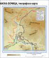
File:Šargan Eight Map-sr.svg

Size of this PNG preview of this SVG file: 511 × 599 pixels. Other resolutions: 205 × 240 pixels | 409 × 480 pixels | 655 × 768 pixels | 873 × 1,024 pixels | 1,747 × 2,048 pixels | 673 × 789 pixels.
Original file (SVG file, nominally 673 × 789 pixels, file size: 753 KB)
File history
Click on a date/time to view the file as it appeared at that time.
| Date/Time | Thumbnail | Dimensions | User | Comment | |
|---|---|---|---|---|---|
| current | 22:53, 29 January 2011 |  | 673 × 789 (753 KB) | Ivan25 | added Drvengrad - ethnovillage. |
| 22:30, 29 January 2011 |  | 673 × 789 (748 KB) | Ivan25 | some adjustement. | |
| 22:17, 29 January 2011 |  | 673 × 789 (535 KB) | Ivan25 | Minor changes | |
| 22:14, 29 January 2011 |  | 673 × 789 (531 KB) | Ivan25 | {{Information |Description ={{en|1=Map of Šargan Eight, narrow gauge railroad in Western Serbia}} {{sr|1=Мапа Шарганске осмице, с приказом свих тунела и стајалишта.}} |Source ={{own}} |Author |
File usage
The following page uses this file:
Global file usage
The following other wikis use this file:
- Usage on az.wikipedia.org
- Usage on bg.wikipedia.org
- Usage on cs.wikipedia.org
- Usage on de.wikipedia.org
- Usage on hu.wikipedia.org
- Usage on it.wikipedia.org
- Usage on lt.wikipedia.org
- Usage on mk.wikipedia.org
- Usage on pl.wikipedia.org
- Usage on ru.wikipedia.org
- Usage on sl.wikipedia.org
- Usage on sr.wikipedia.org
- Usage on sv.wikipedia.org


 French
 Deutsch