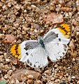
File:Common Orange Tip (Colotis evenina) female (32718355393).jpg

Original file (3,045 × 3,225 pixels, file size: 6.91 MB, MIME type: image/jpeg)

Summary

Description

Colotis evenina nom. subsp. evenina, cf. f. deidamoides
"Mathekenyane, H1-1 Road South of Skukuza, Kruger NP, Mpumalanga, SOUTH AFRICA"

Afrikaans: Wyfie van die Oranjepuntjie, blykbaar 'n buiteseisoenale droëseisoenvorm, afgeneem te Granokop in die suidelike Krugerwildtuin, Mpumalanga, Suid-Afrika. Die droëseisoen- of droëstreekvorme deidamoides en lerichei het beperkte swarterige vlerkmerke. Larwes van die spesie voed op blare van Witgatbome of Kapperbosse wat van dorre tot mesiese streke aangetref word.
English: Female of the nominate subspecies of the Common orange tip at Mathekenyane, a granite outcrop near the H1-1 tourist road south of Skukuza, in the Kruger National Park, Mpumalanga, SOUTH AFRICA. The lack of extensive swarthy wing markings on this specimen suggests the dry season form, f. deidamoides, despite being photographed in November. The larvae of the species feeds on Boscia albitrunca, which is present at Mathekenyane, and Capparis spp., both plants that occur in mesic to arid areas.
Date
Source Common Orange Tip (Colotis evenina) female
Author Bernard DUPONT from FRANCE
Camera location25° 04′ 02.69″ S, 31° 33′ 06.87″ E Kartographer map based on OpenStreetMap.View this and other nearby images on: OpenStreetMapinfo

Licensing

w:en:Creative Commons
attribution share alike
This file is licensed under the Creative Commons Attribution-Share Alike 2.0 Generic license.
You are free:
  • to share – to copy, distribute and transmit the work
  • to remix – to adapt the work
Under the following conditions:
  • attribution – You must give appropriate credit, provide a link to the license, and indicate if changes were made. You may do so in any reasonable manner, but not in any way that suggests the licensor endorses you or your use.
  • share alike – If you remix, transform, or build upon the material, you must distribute your contributions under the same or compatible license as the original.
This image was originally posted to Flickr by berniedup at https://flickr.com/photos/65695019@N07/32718355393. It was reviewed on 26 March 2017 by FlickreviewR and was confirmed to be licensed under the terms of the cc-by-sa-2.0.

26 March 2017

Captions

Add a one-line explanation of what this file represents

Items portrayed in this file

depicts

25°4'2.694"S, 31°33'6.869"E

26 November 2016

0.0015625 second

146 millimetre

image/jpeg

17a4355e2e7bff4e022de991d5c99533efe0ffbf

7,248,615 byte

3,225 pixel

3,045 pixel

File history

Click on a date/time to view the file as it appeared at that time.

Date/TimeThumbnailDimensionsUserComment
current00:45, 26 March 2017Thumbnail for version as of 00:45, 26 March 20173,045 × 3,225 (6.91 MB)Helmy ovedTransferred from Flickr via Flickr2Commons

The following page uses this file:

Global file usage

The following other wikis use this file:

Metadata