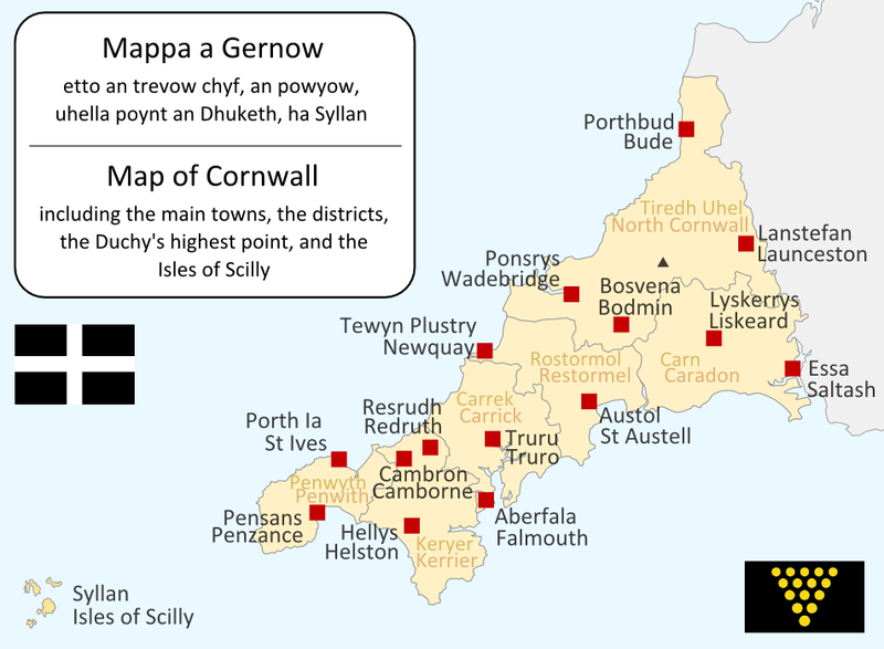
File:CornwallKernowMappa.png

Size of this preview: 800 × 587 pixels. Other resolutions: 320 × 235 pixels | 640 × 469 pixels | 952 × 698 pixels.
Original file (952 × 698 pixels, file size: 167 KB, MIME type: image/png)
File history
Click on a date/time to view the file as it appeared at that time.
| Date/Time | Thumbnail | Dimensions | User | Comment | |
|---|---|---|---|---|---|
| current | 19:09, 23 June 2011 |  | 952 × 698 (167 KB) | Lader Gwiader | improve, SWF, place names from "A Concise Dictionary of Cornish Place Names" |
| 04:38, 21 August 2005 |  | 643 × 469 (30 KB) | QuartierLatin1968 | one or two grammatical fixes, less jarring colours | |
| 17:33, 14 April 2005 |  | 644 × 474 (21 KB) | QuartierLatin1968 | I made this map myself in September 2004. It is bilingual in Cornish and English, and shows the modern-day administrative boundaries of Cornwall and the larger towns. {{GFDL}} |
File usage
The following 2 pages use this file:
Global file usage
The following other wikis use this file:
- Usage on af.wikipedia.org
- Usage on an.wikipedia.org
- Usage on ast.wikipedia.org
- Usage on br.wikipedia.org
- Usage on ca.wikipedia.org
- Usage on cs.wikipedia.org
- Usage on cy.wikipedia.org
- Usage on el.wiktionary.org
- Usage on eo.wikipedia.org
- Usage on es.wikipedia.org
- Usage on frr.wikipedia.org
- Usage on fr.wikipedia.org
- Usage on fy.wikipedia.org
- Usage on gd.wikipedia.org
- Usage on he.wikipedia.org
- קורנית (שפה)
- תבנית:הידעת? 10 ביולי - סדרה 2
- פורטל:הממלכה המאוחדת/הידעת?/קטעי הידעת?
- פורטל:בלשנות/הידעת?/קטעי הידעת
- פורטל:בלשנות/הידעת?/10
- פורטל:הממלכה המאוחדת/הידעת?/17
- תבנית:הידעת? 10 ביולי 2013
- ויקיפדיה:הידעת?/2013/יולי
- ויקיפדיה:הידעת?/2016/יולי
- תבנית:הידעת? 12 ביולי 2016
- ויקיפדיה:הידעת?/2018/יולי
- תבנית:הידעת? 19 ביולי 2018
- ויקיפדיה:הידעת?/2019/יולי
- תבנית:הידעת? 10 ביולי 2019
- ויקיפדיה:הידעת?/2021/יולי
- תבנית:הידעת? 10 ביולי 2021
View more global usage of this file.


 French
 Deutsch