
 French
 Deutsch
File:Karte Hasetal.gif
No higher resolution available.
Karte_Hasetal.gif (400 × 331 pixels, file size: 26 KB, MIME type: image/gif)
| This is a file from the Wikimedia Commons. Information from its description page there is shown below. Commons is a freely licensed media file repository. You can help. |
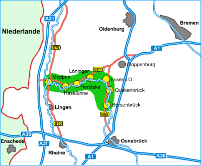
Summary
| Description | Lage des Hasetals und Verlauf des Flusses Hase |
| Date | |
| Source | http://www.hasetal.de |
| Author | http://www.hasetal.de |
| Permission (Reusing this file) |
Licensing
 | Permission is granted to copy, distribute and/or modify this document under the terms of the GNU Free Documentation License, Version 1.2 or any later version published by the Free Software Foundation; with no Invariant Sections, no Front-Cover Texts, and no Back-Cover Texts. A copy of the license is included in the section entitled GNU Free Documentation License. |
| This file is licensed under the Creative Commons Attribution-Share Alike 3.0 Unported license. | ||
| ||
| This licensing tag was added to this file as part of the GFDL licensing update. |
File history
Click on a date/time to view the file as it appeared at that time.
| Date/Time | Thumbnail | Dimensions | User | Comment | |
|---|---|---|---|---|---|
| current | 17:15, 1 October 2007 | | 400 × 331 (26 KB) | Lencer | {{Information| |Description=Lage des Hasetals und Verlauf des Flusses Hase |Source=[http://www.hasetal.de http://www.hasetal.de], Erlaubnis liegt als Email vor und wird in Kürze an [email protected] übers |
File usage
The following pages on the English Wikipedia use this file (pages on other projects are not listed):
Global file usage
The following other wikis use this file:
- Usage on de.wikipedia.org
- Usage on de.wikivoyage.org
- Usage on eo.wikipedia.org
- Usage on et.wikipedia.org
- Usage on fr.wikipedia.org
- Usage on fy.wikipedia.org