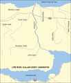
File:Lyre River Map.PNG

Size of this preview: 493 × 600 pixels. Other resolutions: 197 × 240 pixels | 574 × 698 pixels.
Original file (574 × 698 pixels, file size: 24 KB, MIME type: image/png)
File history
Click on a date/time to view the file as it appeared at that time.
| Date/Time | Thumbnail | Dimensions | User | Comment | |
|---|---|---|---|---|---|
| current | 02:47, 25 September 2007 |  | 574 × 698 (24 KB) | Ruhrfisch | Added scale (miles and kilometers) and label at bottom of map, all other information is the same ~~~~ |
| 17:54, 14 September 2007 |  | 574 × 667 (22 KB) | Ruhrfisch | "Crescent Lake", now fixed as "Lake Crescent", stream labels all horizontal, narrowed Lyre River course (from 3 px to 2 px wide, generally), all other information the same | |
| 17:48, 13 September 2007 |  | 574 × 667 (22 KB) | Ruhrfisch | Fixed typo (de not De), added caption, removed double wide border on left side. All other information the same | |
| 21:52, 12 September 2007 |  | 575 × 667 (22 KB) | Ruhrfisch | {{Information| |Description= Map of Lyre River in Clallam County, Washington, United States |Source= taken from US Census website [http://factfinder.census.gov/] and modified by User:Ruhrfisch. |Date= September 2007 |Author= US Census, Ruhrfisch |Pe |
File usage
The following page uses this file:
Global file usage
The following other wikis use this file:
- Usage on de.wikipedia.org
- Usage on fr.wikipedia.org
- Usage on nl.wikipedia.org


 French
 Deutsch
