
 French
 Deutsch
File:Mediterranean chart fourteenth century2.jpg

Original file (5,486 × 4,009 pixels, file size: 17.24 MB, MIME type: image/jpeg)
| This is a file from the Wikimedia Commons. Information from its description page there is shown below. Commons is a freely licensed media file repository. You can help. |
| This is a featured picture, which means that members of the community have identified it as one of the finest images on the English Wikipedia, adding significantly to its accompanying article. If you have a different image of similar quality, be sure to upload it using the proper free license tag, add it to a relevant article, and nominate it. |
| This image was selected as picture of the day on the English Wikipedia for October 22, 2009. |
|
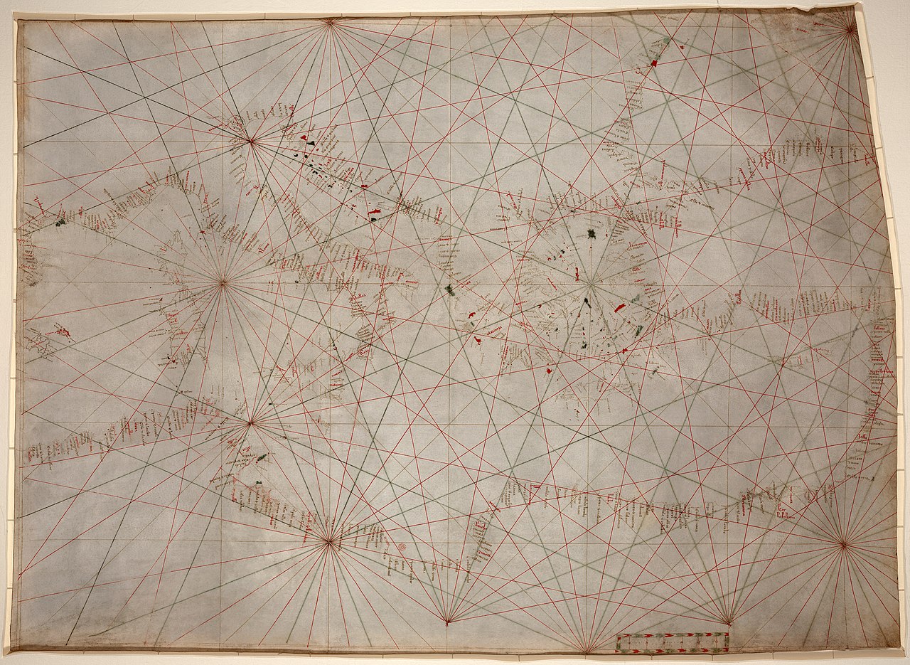
| This is a retouched picture, which means that it has been digitally altered from its original version. Modifications: stains, dirt, and creases removed, some lines reconstructed, selective brightness changes, histogram adjusted, and colors balanced. The original can be viewed here: Mediterranean chart fourteenth century.jpg:
|
Summary
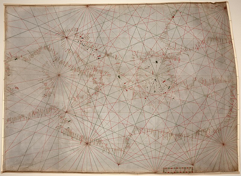
| Description | Anonymous nautical chart in portolan style probably drawn in Genoa. Covers Mediterranean Sea from the Balearic Islands to the Levantine coast; also covers western part of Black Sea. Oldest original cartographic artifact in the Library of Congress. Title from printed label on box in which the map is housed. Pen-and-ink (red/green/brown). Matted and mounted between sheets of transparent lucite. Sheet cut into the shape of an irregular rectangle. Imperfect: Vertically fold-lined at center, cracked, annotated in pencil on verso. Includes bar scale with unidentified divisions. The green rhumb lines on the recto are also visible on the verso. Scale [ca. 1:5,500,000]. | ||||
| Date | between circa 1320 and circa 1350 | ||||
| Source | Library of Congress[1] | ||||
| Author | anonymous, probably Genoan | ||||
| Permission (Reusing this file) |
| ||||
| Other versions | Derivative works of this file: | ||||
.jpg)
.jpg)
File history
Click on a date/time to view the file as it appeared at that time.
| Date/Time | Thumbnail | Dimensions | User | Comment | |
|---|---|---|---|---|---|
| current | 02:53, 18 January 2009 | | 5,486 × 4,009 (17.24 MB) | Durova | {{Information |Description=Anonymous nautical chart in portolan style probably drawn in Genoa. Covers Mediterranean Sea from the Balearic Islands to the Levantine coast; also covers western part of Black Sea. Oldest original cartographic artifact in t |
File usage
- Portolan chart
- Rule of marteloio
- User:Durova/Featured credits at the Turkish language Wikipedia
- User:Durova/Featured picture gallery/2009
- User:Walrasiad/Maps
- User talk:Durova/Archive 65
- User talk:Durova/Archive 73
- Wikipedia:Featured picture candidates/January-2009
- Wikipedia:Featured picture candidates/Portolan chart of the Mediterranean
- Wikipedia:Featured pictures/Diagrams, drawings, and maps/Maps
- Wikipedia:Featured pictures thumbs/15
- Wikipedia:Picture of the day/October 2009
- Wikipedia:Wikipedia Signpost/2009-01-31/Features and admins
- Wikipedia:Wikipedia Signpost/2009-01-31/SPV
- Wikipedia:Wikipedia Signpost/Single/2009-01-31
- Template:POTD/2009-10-22
Global file usage
The following other wikis use this file:
- Usage on ar.wikipedia.org
- Usage on ca.wikipedia.org
- Usage on dtp.wikipedia.org
- Usage on es.wikipedia.org
- Usage on et.wikipedia.org
- Usage on eu.wikipedia.org
- Usage on gl.wikipedia.org
- Usage on he.wikipedia.org
- Usage on hr.wikipedia.org
- Usage on incubator.wikimedia.org
- Usage on it.wikipedia.org
- Usage on ja.wikipedia.org
- Usage on ko.wikipedia.org
- Usage on mn.wikipedia.org
- Usage on ms.wikipedia.org
- Usage on pl.wikipedia.org
- Usage on ps.wikipedia.org
- Usage on pt.wikipedia.org
- Usage on sh.wikipedia.org
- Usage on si.wikipedia.org
- Usage on sl.wikipedia.org
- Usage on sr.wikipedia.org
- Usage on ta.wikipedia.org
- Usage on th.wikipedia.org
- Usage on tr.wikipedia.org
- Portolan haritası
- Kartografya
- Vikipedi:Seçkin resim adayları/Mediterranean chart fourteenth century2.jpg
- Vikipedi:Seçkin resim adayları/Arşiv/Nisan 2009
- Vikipedi:Günün seçkin resmi/Şubat 2010
- Kullanıcı:Durova
- Şablon:GSR/2010-02-19
- Kullanıcı mesaj:Takabeg/Seçkin resimler (Durova)
- Vikipedi:Seçkin resimler/Çizimler, diyagramlar ve haritalar/Haritalar
- Vikipedi:Seçkin resimler/Ana sayfaya çıkmış resimler/2010 listesi
- Vikipedi:Günün seçkin resmi/Mart 2013
- Şablon:GSR/2013-03-20
- Vikipedi:Seçkin resimler/Ana sayfaya çıkmış resimler/2013 listesi
- Vikipedi:Günün seçkin resmi/Aralık 2019
- Şablon:GSR/2019-12-27
- Usage on zh.wikipedia.org