
 French
 Deutsch
File:Millbank Cassell's large-scale map of London c 1867.jpg
No higher resolution available.
Millbank_Cassell's_large-scale_map_of_London_c_1867.jpg (300 × 272 pixels, file size: 28 KB, MIME type: image/jpeg)
| This is a file from the Wikimedia Commons. Information from its description page there is shown below. Commons is a freely licensed media file repository. You can help. |
Summary
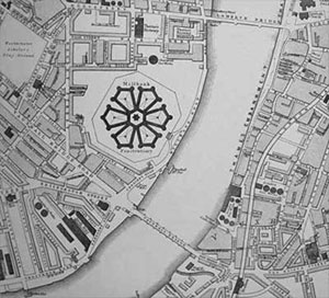
Millbank, Cassell's large scale map of London, 1867. (to the editor: why is Lambeth bridge on the map in 1867 when it wasn't built until 1932?)
- Probably for this reason: "The previous structure was a suspension bridge, 828 feet (252.4 m) long, designed by Peter W. Barlow. Sanctioned by an Act of Parliament in 1860, it opened as a toll bridge in 1862 but doubts about its safety, coupled with its awkwardly steep approaches deterring horse-drawn traffic, meant it soon became used almost solely as a pedestrian crossing."
Licensing
| This work is in the public domain in its country of origin and other countries and areas where the copyright term is the author's life plus 70 years or fewer. | |
| This file has been identified as being free of known restrictions under copyright law, including all related and neighboring rights. | |
File history
Click on a date/time to view the file as it appeared at that time.
| Date/Time | Thumbnail | Dimensions | User | Comment | |
|---|---|---|---|---|---|
| current | 12:34, 31 January 2006 | | 300 × 272 (28 KB) | Bhoeble~commonswiki | Millbank, Cassell's large scale map of London, 1867. Category:Maps of London |
File usage
The following pages on the English Wikipedia use this file (pages on other projects are not listed):
Global file usage
The following other wikis use this file:
- Usage on fr.wikipedia.org
- Usage on ja.wikipedia.org
- Usage on no.wikipedia.org