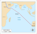
File:Operation Pamphlet 24 Jan - 27 Feb 1943.svg

Size of this PNG preview of this SVG file: 637 × 599 pixels. Other resolutions: 255 × 240 pixels | 510 × 480 pixels | 817 × 768 pixels | 1,089 × 1,024 pixels | 2,178 × 2,048 pixels | 1,075 × 1,011 pixels.
Original file (SVG file, nominally 1,075 × 1,011 pixels, file size: 61 KB)
File history
Click on a date/time to view the file as it appeared at that time.
| Date/Time | Thumbnail | Dimensions | User | Comment | |
|---|---|---|---|---|---|
| current | 04:52, 23 October 2016 |  | 1,075 × 1,011 (61 KB) | Anotherclown | Try to fix scale issue with Malvdives, add some continent / place names for context |
| 22:34, 31 August 2016 |  | 1,075 × 1,011 (55 KB) | Nick-D | Thicker route line - thanks to AC for instructions! | |
| 10:32, 31 August 2016 |  | 1,075 × 1,011 (55 KB) | Nick-D | Fix error | |
| 10:31, 31 August 2016 |  | 1,075 × 1,011 (56 KB) | Nick-D | Added the route the convoy took | |
| 06:20, 31 August 2016 |  | 1,075 × 1,011 (54 KB) | Anotherclown | Added location of ports etc. used during convoy, some corrections to coast line, add Suez Canal | |
| 21:52, 29 August 2016 |  | 1,075 × 1,011 (43 KB) | Anotherclown | == {{int:filedesc}} == {{Information |Description={{en|Map illustrating en:Operation Pamphlet, which took place 24 January – 27 February 1943.}} |Source=Self created |Date=30 August 2016 |Author=Anotherclown |Permission... |
File usage
The following 3 pages use this file:
Global file usage
The following other wikis use this file:
- Usage on br.wikipedia.org


 French
 Deutsch