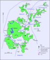
File:Orkney Map.png

Size of this preview: 506 × 600 pixels. Other resolutions: 202 × 240 pixels | 405 × 480 pixels | 788 × 934 pixels.
Original file (788 × 934 pixels, file size: 162 KB, MIME type: image/png)
File history
Click on a date/time to view the file as it appeared at that time.
| Date/Time | Thumbnail | Dimensions | User | Comment | |
|---|---|---|---|---|---|
| current | 06:52, 12 May 2018 |  | 788 × 934 (162 KB) | RokerHRO | clipped unnecessary semi-transparent pixel rows at the top. optipng -o7 -zm1-9 -> reduction by 28% |
| 20:40, 27 April 2012 |  | 788 × 937 (226 KB) | Mikenorton | Corrected labels for Wyre and Egilsay, which were swapped | |
| 13:43, 23 September 2009 |  | 788 × 937 (226 KB) | Mikenorton | {{Information |Description={{en|1=Map of Orkney with main transport links - based on many other maps}} |Source=Own work by uploader |Author=Mikenorton |Date=2009-09-23 |Permission= |other_versions= }} |
File usage
The following 3 pages use this file:
Global file usage
The following other wikis use this file:
- Usage on fr.wikipedia.org
- Usage on gl.wikipedia.org
- Usage on it.wikipedia.org
- Usage on nl.wikipedia.org
- Usage on sl.wikipedia.org
- Usage on war.wikipedia.org


 French
 Deutsch