
 French
 Deutsch
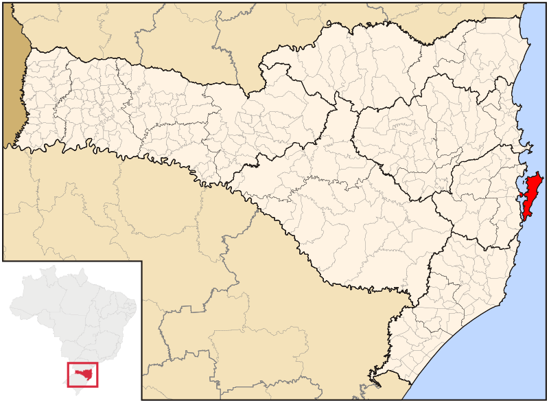
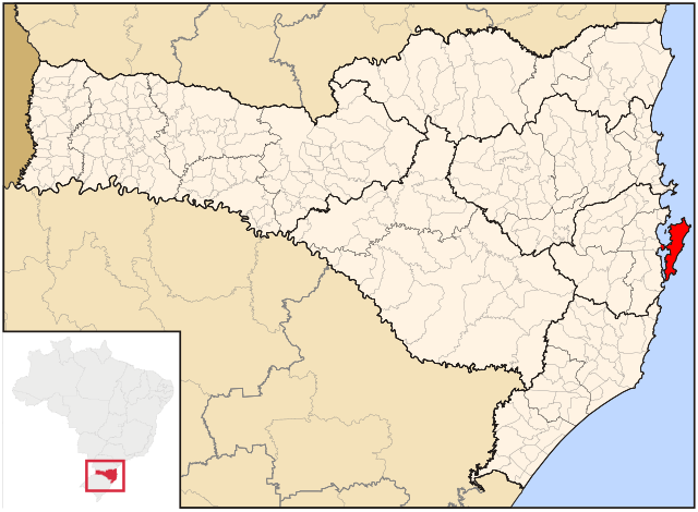
File:SantaCatarina Municip Florianopolis.svg

Size of this PNG preview of this SVG file: 800 × 586 pixels. Other resolutions: 320 × 234 pixels | 640 × 469 pixels | 1,024 × 750 pixels | 1,280 × 938 pixels | 2,560 × 1,876 pixels | 943 × 691 pixels.
Original file (SVG file, nominally 943 × 691 pixels, file size: 623 KB)
| This is a file from the Wikimedia Commons. Information from its description page there is shown below. Commons is a freely licensed media file repository. You can help. |
File history
Click on a date/time to view the file as it appeared at that time.
| Date/Time | Thumbnail | Dimensions | User | Comment | |
|---|---|---|---|---|---|
| current | 16:02, 24 August 2021 | | 943 × 691 (623 KB) | Allice Hunter | Reverted to version as of 06:26, 24 June 2006 (UTC) |
| 15:21, 24 August 2021 |  | 512 × 375 (320 KB) | Allice Hunter | Adjusting | |
| 15:11, 24 August 2021 |  | 512 × 375 (425 KB) | Allice Hunter | Final version | |
| 15:03, 24 August 2021 |  | 512 × 375 (448 KB) | Allice Hunter | Adjusting | |
| 15:01, 24 August 2021 |  | 512 × 375 (590 KB) | Allice Hunter | Those regions no longer exist | |
| 06:26, 24 June 2006 |  | 943 × 691 (623 KB) | Cicerohr | Map locator of Santa Catarina's Florianópolis city |
File usage
The following 2 pages use this file:
Global file usage
The following other wikis use this file:
- Usage on af.wikipedia.org
- Usage on ar.wikipedia.org
- Usage on ast.wikipedia.org
- Usage on bpy.wikipedia.org
- Usage on ca.wikipedia.org
- Usage on ceb.wikipedia.org
- Usage on ckb.wikipedia.org
- Usage on de.wikipedia.org
- Usage on el.wikipedia.org
- Usage on eo.wikipedia.org
- Usage on es.wikipedia.org
- Usage on eu.wikipedia.org
- Usage on fa.wikipedia.org
- Usage on fi.wikipedia.org
- Usage on fr.wikipedia.org
- Usage on ga.wikipedia.org
- Usage on gl.wikipedia.org
- Usage on gn.wikipedia.org
- Usage on he.wikipedia.org
- Usage on hu.wikipedia.org
- Usage on ia.wikipedia.org
- Usage on id.wikipedia.org
- Usage on io.wikipedia.org
- Usage on is.wikipedia.org
- Usage on it.wikipedia.org
- Usage on ja.wikipedia.org
- Usage on lmo.wikipedia.org
- Usage on mr.wikipedia.org
- Usage on nl.wikipedia.org
- Usage on no.wikipedia.org
- Usage on pt.wikipedia.org
- Usage on pt.wikivoyage.org
- Usage on ro.wikipedia.org
- Usage on sco.wikipedia.org
- Usage on sk.wikipedia.org
- Usage on sr.wikipedia.org
- Usage on sv.wikipedia.org
- Usage on th.wikipedia.org
- Usage on tr.wikipedia.org
- Usage on tt.wikipedia.org
View more global usage of this file.