
 French
 Deutsch
File:USA Territorial Growth 1850.jpg

Original file (1,400 × 616 pixels, file size: 124 KB, MIME type: image/jpeg)
| This is a file from the Wikimedia Commons. Information from its description page there is shown below. Commons is a freely licensed media file repository. You can help. |
| US growth maps |
| Animated: large · small |
| Years |
| 1775 · 1790 · 1800 · 1810 · 1820 · 1830 · 1840 · 1850 · 1860 · 1870 · 1880 · 1900 · 1920 |
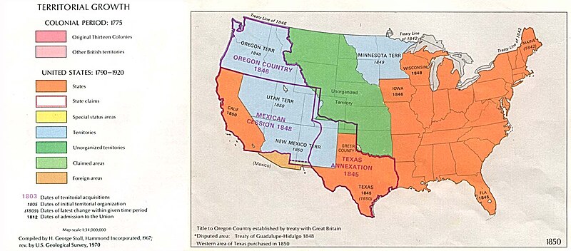
Map of U.S. Territorial Growth (1850) from the Perry-Castañeda Library Map Collection, "...the maps scanned by the University of Texas Libraries and served from this web site are in the public domain. No permissions are needed to copy them. You may download them and use them as you wish."
This image can be found at U.S. Territorial Growth 1850.
"Courtesy of the University of Texas Libraries, The University of Texas at Austin."
Other versions: 
| This work is in the public domain in its country of origin and other countries and areas where the copyright term is the author's life plus 70 years or fewer. | |
| This file has been identified as being free of known restrictions under copyright law, including all related and neighboring rights. | |
File history
Click on a date/time to view the file as it appeared at that time.
| Date/Time | Thumbnail | Dimensions | User | Comment | |
|---|---|---|---|---|---|
| current | 06:18, 4 October 2005 | | 1,400 × 616 (124 KB) | Lordkinbote~commonswiki | Map of U.S. Territorial Growth (1850) from the Perry-Castañeda Library Map Collection. This image can be found at [http://www.lib.utexas.edu/maps/united_states/us_terr_1850.jpg]. |
File usage
Global file usage
The following other wikis use this file:
- Usage on ca.wikipedia.org
- Usage on de.wikipedia.org
- Usage on es.wikinews.org
- Usage on hu.wikipedia.org
- Usage on hy.wikipedia.org
- Usage on it.wikipedia.org
- Usage on ja.wikipedia.org
- Usage on la.wikipedia.org
- Usage on nl.wikipedia.org
- Usage on no.wikipedia.org
- Usage on pl.wikipedia.org
- Usage on pt.wikipedia.org
- Usage on ro.wikipedia.org
- Usage on ru.wikipedia.org
- Usage on simple.wikipedia.org
- Usage on uk.wikipedia.org