
 French
 Deutsch
File:Wisteria Lane map, season 1.svg

Size of this PNG preview of this SVG file: 800 × 471 pixels. Other resolutions: 320 × 188 pixels | 640 × 377 pixels | 1,024 × 603 pixels | 1,280 × 754 pixels | 2,560 × 1,508 pixels | 1,056 × 622 pixels.
Original file (SVG file, nominally 1,056 × 622 pixels, file size: 32 KB)
| This is a file from the Wikimedia Commons. Information from its description page there is shown below. Commons is a freely licensed media file repository. You can help. |
Summary
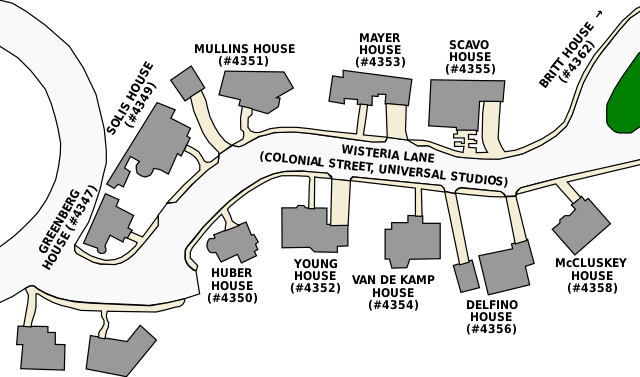
| Description | English: Map of the Wisteria Lane (otherwise known as Colonial Street), showing house numbers and residents in season one of Desperate Housewives |
| Date | (UTC) |
| Source | (Original text : Own work.
|
| Author | Matthewedwards : Chat |
| Permission (Reusing this file) | (Any use of this map can be made as long as you credit me (Matthew Edwards) as the author and distribute the copies and derivative works under the same license(s) as the one(s) stated below. A message on my talk page with a reply address would be appreciated.) |
| Other versions | File:WisteriaLane.svg |
Licensing
Matthewedwards at English Wikipedia, the copyright holder of this work, hereby publishes it under the following licenses:
 | Permission is granted to copy, distribute and/or modify this document under the terms of the GNU Free Documentation License, Version 1.2 or any later version published by the Free Software Foundation; with no Invariant Sections, no Front-Cover Texts, and no Back-Cover Texts. A copy of the license is included in the section entitled GNU Free Documentation License. |
This file is licensed under the Creative Commons Attribution-Share Alike 4.0 International, 3.0 Unported, 2.5 Generic, 2.0 Generic and 1.0 Generic license.
Attribution: Matthewedwards at English Wikipedia
- You are free:
- to share – to copy, distribute and transmit the work
- to remix – to adapt the work
- Under the following conditions:
- attribution – You must give appropriate credit, provide a link to the license, and indicate if changes were made. You may do so in any reasonable manner, but not in any way that suggests the licensor endorses you or your use.
- share alike – If you remix, transform, or build upon the material, you must distribute your contributions under the same or compatible license as the original.
You may select the license of your choice.
Original upload log
Transferred from en.wikipedia to Commons by Sesu Prime.
The original description page was here. All following user names refer to en.wikipedia.
- 2009-07-01 05:32 Matthewedwards 1056×622× (32690 bytes) Adding house numbers
- 2009-07-01 05:11 Matthewedwards 1056×622× (29133 bytes) {{Information |Description = Map of the [[Wisteria Lane]] (otherwise known as [[Colonial Street]] |Source = Own work.<br /> * Referenced from a Universal Studios Hollywood tour map of Colonial Street, and {{cite book |last1=Cherry |first1=Mar
File history
Click on a date/time to view the file as it appeared at that time.
| Date/Time | Thumbnail | Dimensions | User | Comment | |
|---|---|---|---|---|---|
| current | 00:55, 1 May 2010 | | 1,056 × 622 (32 KB) | Sesu Prime | {{Information |Description={{en|Map of the en:Wisteria Lane (otherwise known as en:Colonial Street), showing house numbers and residents in season one of ''Desperate Housewives''}} |Source=Transferred fr |
File usage
The following pages on the English Wikipedia use this file (pages on other projects are not listed):
Global file usage
The following other wikis use this file:
- Usage on bg.wikipedia.org
- Usage on cs.wikipedia.org
- Usage on es.wikipedia.org
- Usage on it.wikipedia.org
- Usage on ja.wikipedia.org
- Usage on nl.wikipedia.org
- Usage on pt.wikipedia.org
- Usage on ru.wikipedia.org