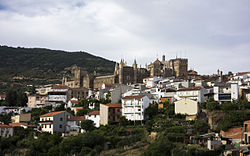
Guadalupe, Cáceres
You can help expand this article with text translated from the corresponding article in Spanish. (June 2020) Click [show] for important translation instructions.
|
Guadalupe | |
|---|---|
 | |
| Coordinates: 39°27′10″N 5°19′39″W / 39.45278°N 5.32750°W | |
| Country | Spain |
| Autonomous community | Extremadura |
| Province | Cáceres |
| Area | |
| • Total | 68.19 km2 (26.33 sq mi) |
| Elevation | 640 m (2,100 ft) |
| Population (2018)[1] | |
| • Total | 1,887 |
| • Density | 28/km2 (72/sq mi) |
| Time zone | UTC+1 (CET) |
| • Summer (DST) | UTC+2 (CEST) |
 | |
Guadalupe is a municipality of Spain located in the province of Cáceres, Extremadura.[2] It has a total area of 68.19 km2 and, as of 1 January 2021, a registered population of 1,822.[2] The monastery of Santa María de Guadalupe is situated here.
Geography
[edit]The Guadalupe River has its origins near the town in the Sierra de las Villuercas. Its highest point, the Pico la Villuerca reaches an altitude of 1603 m.[3]
See also
[edit]References
[edit]- ^ Municipal Register of Spain 2018. National Statistics Institute.
- ^ a b "Datos del Registro de Entidades Locales". Ministerio de Asuntos Económicos y Transformación Digital. Retrieved 23 May 2022.
- ^ Pico la Villuerca Archived 2013-12-16 at the Wayback Machine
Wikimedia Commons has media related to Guadalupe.


 French
 Deutsch

