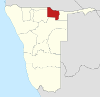
Kavango West
Kavango West | |
|---|---|
Region | |
 The Kavango West Region (dark grey) in Namibia | |
| Country | Namibia |
| Seat | Nkurenkuru |
| Government | |
| • Governor | Sirkka Ausiku[1] (SWAPO) |
| Area | |
| • Total | 24,591 km2 (9,495 sq mi) |
| Population (2023 census)[2] | |
| • Total | 123,266 |
| • Density | 5.0/km2 (13/sq mi) |
| Time zone | UTC+2 (CAT) |
| Website | kavangowestrc |
Kavango West is one of the fourteen regions of Namibia. Its capital and only self-governed settlement is Nkurenkuru, its governor is Sirkka Ausiku. The Region was created in 2013 when the Kavango Region was split into Kavango East and Kavango West. In the north, Kavango West borders the Cuando Cubango Province of Angola. Domestically, it borders the regions of Kavango East to the east, Otjozondjupa to the south, Oshikoto to the west and Ohangwena to the northwest.
Because of its rather high rainfall compared to most other parts of Namibia and its location on the Kavango River after which it was named, this region has agricultural potential for the cultivation of a variety of crops, as well as for organised forestry and agro-forestry, which stimulates furniture making and related industries. Kavango West and its sister region Kavango East are nevertheless the poorest regions in Namibia.[3]
Politics
[edit]The Fourth Delimitation Commission of Namibia, responsible for recommending on the country's administrative divisions suggested in August 2013 to split the Kavango Region into two. The president Hifikepunye Pohamba enacted the recommendations. As a result, the new Regions of Kavango East and Kavango West have been created.[4] As of 2020, Kavango West had 23,804 registered voters.[5]
Administrative division
[edit]The region is subdivided into eight electoral constituencies:[6][4]
In the 2015 regional elections SWAPO won in all eight constituencies.[7] SWAPO also won all constituencies in the 2020 regional election, all of them by a landslide, and with overall more than 90% of the votes.[5]
Governors
[edit]The first Governor of Kavango West was Samuel Mbambo, former Governor of the Kavango Region and sitting Governor of Kavango East.[6] On 27 April 2014 Sirkka Ausiku, formerly Permanent Secretary of the Ministry of Regional and Local Government, Housing and Rural Development, was appointed.[8] He kept his position in 2015 in president Hage Geingob's new government.[1]
Health services
[edit]Kavango East and West Regional Health Directorate has the following facilities. Hospitals = 1. Health Centers = 2. Primary Health Care Clinics = 26.[9]
Population
[edit]The region is characterised by an extremely uneven population distribution. The interior is very sparsely inhabited, while the northernmost strip, especially along the Kavango River, has a high population concentration.
Economy and infrastructure
[edit]The region contains a multi-country conservation park and six locally managed wildlife reserves.[10][11]
Oil exploration
[edit]ReconAfrica, a petroleum exploration company headquartered in Canada, has obtained exploration licenses for more than 13,600 square miles of land in the Kavango West region of Namibia and in Botswana. In January 2021 ReconAfrica announced the start of drilling operations on the first exploration well. Environmental activists have expressed concern that ReconAfrica's plans for its test wells have not been properly vetted through Namibia's environmental review process, however ReconAfrica and both the governments of Namibia and Botswana have stated that the company's activities have followed due process and that no fracking will occur. The drilling license does not include any of the protected areas.[12][13][14]
Data and statistics
[edit]- Capital:Nkurenkuru
- Governor:Sirkka Ausiku
- Land area, km2:23,166 (2011)
- Population, persons:86,529 (2011)
- Population density, people/km2:3.9 (2016)
- Household average size, persons:6.3 (2011)
- Life expectancy at birth, Male, years:47 (2011)
- Life expectancy at birth, Female, years:56 (2011)
- Literacy rate, 15+ years, %:77 (2011)
- Population in labour force, %:No data
- Main source of income: farming, %:60 (2011)
- Severely Poor, %:No data
- Poverty Inequality:No data
- Households using Electricity for Lighting, %:No data
- Households using Wood for Cooking, %:No data
- Households using Wood for Heating, %:No data[15]
References
[edit]- ^ a b "President announces governors". The Namibian. 10 April 2015. Archived from the original on 14 April 2015. Retrieved 14 April 2015.
- ^ "2023 Population & Housing Census Preliminary Report" (PDF). Statistics Namibia.
- ^ Kandjimi, Shoki (5 November 2020). "Kavango East not a poor region - governor". New Era. p. 1.
- ^ a b Nakale, Albertina (9 August 2013). "President divides Kavango into two". New Era. allafrica.com. Archived from the original on 22 October 2014. Retrieved 16 August 2013.
- ^ a b "Regional Council 2020 Election Results". Interactive map. Electoral Commission of Namibia. 18 January 2021. Archived from the original on 12 June 2021. Retrieved 11 May 2021.
- ^ a b Haufiku, Mathias (22 August 2013). "Kavango awaits second governor". New Era. Archived from the original on 31 August 2013. Retrieved 27 August 2013.
- ^ "Regional Council Election Results 2015". Electoral Commission of Namibia. 3 December 2015. pp. 7–8. Archived from the original on 8 December 2015.
- ^ "New broom in new region". The Namibian. Vol. 28, no. 76. NAMPA. 28 April 2014. p. 2.
- ^ "kavango west - Google Search". www.google.com. Retrieved 2023-09-09.
- ^ ReconAfrica starts drilling on first well in Kavango Basin, Namibia
- ^ Oil drilling, possible fracking planned for Okavango region—elephants’ last stronghold
- ^ "ReconAfrica Environmental, Social, and Governance". Retrieved 20 May 2021.
- ^ "Press release - Clarity on explorative activities by Reconnaissance Energy Botswana". twitter.com (Press release). Retrieved 30 April 2021.
- ^ "Factual Response to article titled: "Oil Drillers Threaten Okavango Ecosystem"". mme.gov.na. Retrieved 30 April 2021.
- ^ "Kavango West - Namibia | Data and Statistics - knoema.com". Knoema. Retrieved 2023-09-09.
External links
[edit]- Kavango West Regional Council Official website


 French
 Deutsch