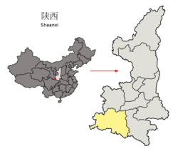
Liuba County
Liuba County 留坝县 Liupa | |
|---|---|
 Location in Hanzhong | |
 Hanzhong in Shaanxi | |
| Country | People's Republic of China |
| Province | Shaanxi |
| Prefecture-level city | Hanzhong |
| Area | |
• County | 1,970 km2 (760 sq mi) |
| Elevation | 1,547 m (5,075 ft) |
| Highest elevation | 2,610 m (8,560 ft) |
| Lowest elevation | 585 m (1,919 ft) |
| Population (2018) | |
• County | 41,882[1] |
| • Rural | 33,947 |
| Time zone | UTC+8 (China standard time) |
| Postal Code | 724100 |
| Website | www |
Liuba County (simplified Chinese: 留坝县; traditional Chinese: 留垻縣; pinyin: Liúbà Xiàn) is a county under the administration of Hanzhong City, in the southwest of Shaanxi province, China. It is the northernmost county-level division of Hanzhong.
The Zhang Liang temple is located in Liuba, Zhang Liang supposedly lived in reclusion at the site.[2][3] There is also a 4000-year old Gingko tree in the county.[4][5]
Administrative divisions
[edit]As 2019, Liuba County is divided to 1 subdistrict and 7 towns.[6]
- Subdistricts
- Zibai Subdistrict (紫柏街道)
- Towns
|
|
Climate
[edit]| Climate data for Liuba, elevation 1,039 m (3,409 ft), (1991–2020 normals, extremes 1981–2010) | |||||||||||||
|---|---|---|---|---|---|---|---|---|---|---|---|---|---|
| Month | Jan | Feb | Mar | Apr | May | Jun | Jul | Aug | Sep | Oct | Nov | Dec | Year |
| Record high °C (°F) | 18.1 (64.6) | 22.7 (72.9) | 29.7 (85.5) | 32.6 (90.7) | 34.7 (94.5) | 37.1 (98.8) | 36.7 (98.1) | 36.3 (97.3) | 35.3 (95.5) | 28.1 (82.6) | 24.2 (75.6) | 19.3 (66.7) | 37.1 (98.8) |
| Mean daily maximum °C (°F) | 7.0 (44.6) | 9.6 (49.3) | 14.7 (58.5) | 20.9 (69.6) | 24.0 (75.2) | 27.2 (81.0) | 28.9 (84.0) | 28.1 (82.6) | 22.5 (72.5) | 17.7 (63.9) | 13.1 (55.6) | 8.3 (46.9) | 18.5 (65.3) |
| Daily mean °C (°F) | 0.5 (32.9) | 3.3 (37.9) | 7.7 (45.9) | 13.0 (55.4) | 16.4 (61.5) | 20.0 (68.0) | 22.5 (72.5) | 21.6 (70.9) | 17.0 (62.6) | 11.7 (53.1) | 6.5 (43.7) | 1.6 (34.9) | 11.8 (53.3) |
| Mean daily minimum °C (°F) | −3.9 (25.0) | −1.0 (30.2) | 2.5 (36.5) | 7.1 (44.8) | 10.8 (51.4) | 14.6 (58.3) | 17.9 (64.2) | 17.4 (63.3) | 13.6 (56.5) | 8.1 (46.6) | 2.2 (36.0) | −2.8 (27.0) | 7.2 (45.0) |
| Record low °C (°F) | −13.0 (8.6) | −11.4 (11.5) | −8.9 (16.0) | −2.8 (27.0) | 1.0 (33.8) | 6.1 (43.0) | 9.4 (48.9) | 9.3 (48.7) | 2.7 (36.9) | −6.4 (20.5) | −8.6 (16.5) | −16.0 (3.2) | −16.0 (3.2) |
| Average precipitation mm (inches) | 5.5 (0.22) | 11.2 (0.44) | 26.1 (1.03) | 49.2 (1.94) | 84.0 (3.31) | 107.1 (4.22) | 147.9 (5.82) | 143.8 (5.66) | 126.2 (4.97) | 71.3 (2.81) | 23.6 (0.93) | 5.6 (0.22) | 801.5 (31.57) |
| Average precipitation days (≥ 0.1 mm) | 5.3 | 6.5 | 9.3 | 9.7 | 13.0 | 12.8 | 15.0 | 14.1 | 15.1 | 13.4 | 8.3 | 4.9 | 127.4 |
| Average snowy days | 7.8 | 5.4 | 2.3 | 0.2 | 0 | 0 | 0 | 0 | 0 | 0.1 | 1.5 | 4.6 | 21.9 |
| Average relative humidity (%) | 65 | 65 | 65 | 67 | 73 | 77 | 81 | 82 | 86 | 84 | 75 | 67 | 74 |
| Mean monthly sunshine hours | 120.5 | 105.2 | 136.9 | 172.2 | 188.5 | 177.4 | 180.9 | 171.7 | 100.6 | 103.7 | 115.4 | 127.0 | 1,700 |
| Percent possible sunshine | 38 | 34 | 37 | 44 | 44 | 41 | 42 | 42 | 27 | 30 | 37 | 42 | 38 |
| Source: China Meteorological Administration[7][8] | |||||||||||||
Transport
[edit]References
[edit]- ^ "China Population www.ceicdata.com". ceicdata. Retrieved 2021-01-04.
- ^ "Temple of Marquis Liu 留侯祠 | China Heritage Quarterly". www.chinaheritagequarterly.org. Retrieved 2021-02-07.
- ^ "Zhang Liang Temple". www.hanzhong.gov.cn. Retrieved 2021-02-07.
- ^ "留坝概况 - 留坝概况 - 留坝县人民政府". www.liuba.gov.cn. Retrieved 2021-02-07.
- ^ sina_mobile (2019-11-22). "自驾中国最美公路高江路,车轮悬空差点掉河". k.sina.cn. Retrieved 2021-02-07.
- ^ "统计用区划代码 www.stats.gov.cn" (in Chinese). XZQH. Retrieved 2021-01-02.
- ^ 中国气象数据网 – WeatherBk Data (in Simplified Chinese). China Meteorological Administration. Retrieved 26 August 2023.
- ^ 中国气象数据网 (in Simplified Chinese). China Meteorological Administration. Retrieved 26 August 2023.
33°36′N 106°55′E / 33.600°N 106.917°E


 French
 Deutsch