Malintrat
Malintrat | |
|---|---|
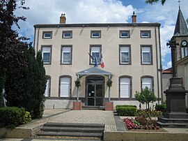
 The town hall in Malintrat | |
| Coordinates: 45°48′57″N 3°11′12″E / 45.8158°N 3.1867°E | |
| Country | France |
| Region | Auvergne-Rhône-Alpes |
| Department | Puy-de-Dôme |
| Arrondissement | Riom |
| Canton | Gerzat |
| Intercommunality | CA Riom Limagne et Volcans |
| Government | |
| • Mayor (2020–2026) | Andre Magnoux[1] |
Area 1 | 8.16 km2 (3.15 sq mi) |
| Population (2021)[2] | 1,138 |
| • Density | 140/km2 (360/sq mi) |
| Time zone | UTC+01:00 (CET) |
| • Summer (DST) | UTC+02:00 (CEST) |
| INSEE/Postal code | 63204 /63510 |
| Elevation | 313–332 m (1,027–1,089 ft) |
| 1 French Land Register data, which excludes lakes, ponds, glaciers > 1 km2 (0.386 sq mi or 247 acres) and river estuaries. | |
Malintrat (French pronunciation: [malɛ̃tʁa]) is a commune in the Puy-de-Dôme département in Auvergne-Rhône-Alpes in central France.[3]
Malintrat is located at east of Clermont-Ferrand between autoroutes A710 and A720, north of the Clermont-Ferrand/Auvergne airport in Aulnat. Malintrat forms part of the Clermont-Ferrand urban area.
History
[edit]In 1839, part of the commune separated to form a new commune, Aulnat.[4]
Demographics
[edit]
|
| |||||||||||||||||||||||||||||||||||||||||||||||||||
| ||||||||||||||||||||||||||||||||||||||||||||||||||||
| Source: EHESS[4] and INSEE[5] | ||||||||||||||||||||||||||||||||||||||||||||||||||||
Notable people
[edit]- Florence Nibart-Devouard, former chair of the Wikimedia Foundation board of trustees
See also
[edit]References
[edit]- ^ "Répertoire national des élus: les maires". data.gouv.fr, Plateforme ouverte des données publiques françaises (in French). 2 December 2020.
- ^ "Populations légales 2021" (in French). The National Institute of Statistics and Economic Studies. 28 December 2023.
- ^ Commune de Malintrat (63204), INSEE
- ^ a b Des villages de Cassini aux communes d'aujourd'hui: Commune data sheet Malintrat, EHESS (in French).
- ^ Population en historique depuis 1968, INSEE
Wikimedia Commons has media related to Malintrat.


 French
 Deutsch


