Nansang
Namsang ဝဵင်းၼမ်ႉၸၢင် နမ့်စန်မြို့ | |
|---|---|
Town | |
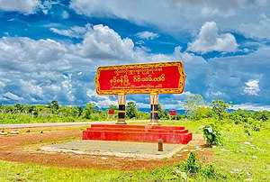
 Sign at entrance of Namsang | |
| Coordinates: 20°53′20″N 97°44′10″E / 20.88889°N 97.73611°E | |
| Country | |
| State | |
| District | Namsang District |
| Township | Namsang Township |
| Area | |
| • Total | 1,594.62 sq mi (4,130.0 km2) |
| Elevation | 3,255 ft (992 m) |
| Population | |
| • Total | 26,060 |
| • Density | 16/sq mi (6.3/km2) |
| Time zone | UTC+6.30 (MMT) |
| Area code | 06161 |
Nansang (Burmese: ဝဵင်းၼမ်ႉၸၢင်) or Namsang is a town in Namsang District of Shan State in eastern Myanmar. It is the seat of Nansang Township. It is the biggest settlement of the eastern central area of the Shan State in Myanmar with 26,060 people in 2019. Most residents live in Ward 4, the northwest part of the town.[2] It is 72 miles away from Taunggyi. A pagoda lies in the southern part of the town. It is also known as Taung Paw Pagoda.
Formation of District
[edit]On April 30, 2022, new districts were expanded across the country.[3] Namsang and Kunhing Townships from Loilem District and Mong Nai Township from Langkho District were separated to form as Namsang District.[3] The townships and towns included in Namsang District are as follows
Population and Ethnicity
[edit]Most people are Buddhist. There are nearly thirty Buddhist monasteries. This region has a population of 70,000 people, most of whom are villagers engaged in agriculture. Only 20,000 people live in town. Most people are Shan. There is chauvinism for few people (Burmese, Paoh, Yinn, Ta'ang, Lahu, Lisu, etc).[citation needed]
Education
[edit]Public School
[edit]- No(1) Basic Education High School[4]
- No(2) Basic Education High School (Myoma)
- Myo Oo Basic Education Sub High School
- No(5) Basic Education Sub High School
- Air Army Basic Education High School
Private School
[edit]- Kaung Myat Private High School[5]
- Brightstar Private Basic School
- Pyin Nyar Young Chi Private Basic School
Health Centers
[edit]- General Hospital (25 Bedded)
- Army Hospital , 8th MB (100 Bedded)
- Khaing Myittar Hospital
- Cherry Hospital
- Myat Mon Hospital
- Moe Makha Hospital
Air Bases
[edit]
Myanmar Air Force also utilised civilian airfields as front-line air fields in case of foreign invasion.[7]
Climate
[edit]Namsang has a humid subtropical climate (Köppen climate classification Cwa), closely bordering a subtropical highland climate (Cwb). There is a winter dry season (December–March) and a summer wet-season (April–November). Temperatures are warm throughout the year; the winter months (December–February) are milder but the nights can be quite cool.[8]
| Climate data for Namsang (1981–2010, extremes 2001–2010) | |||||||||||||
|---|---|---|---|---|---|---|---|---|---|---|---|---|---|
| Month | Jan | Feb | Mar | Apr | May | Jun | Jul | Aug | Sep | Oct | Nov | Dec | Year |
| Record high °C (°F) | 28.5 (83.3) | 30.0 (86.0) | 33.0 (91.4) | 36.0 (96.8) | 35.5 (95.9) | 31.5 (88.7) | 29.5 (85.1) | 29.5 (85.1) | 29.5 (85.1) | 30.0 (86.0) | 29.5 (85.1) | 27.5 (81.5) | 36.0 (96.8) |
| Mean daily maximum °C (°F) | 23.8 (74.8) | 26.0 (78.8) | 29.0 (84.2) | 30.2 (86.4) | 27.7 (81.9) | 26.6 (79.9) | 26.0 (78.8) | 25.5 (77.9) | 25.5 (77.9) | 25.0 (77.0) | 23.5 (74.3) | 22.3 (72.1) | 25.9 (78.6) |
| Mean daily minimum °C (°F) | 4.2 (39.6) | 6.8 (44.2) | 10.7 (51.3) | 14.0 (57.2) | 15.1 (59.2) | 16.1 (61.0) | 16.2 (61.2) | 15.8 (60.4) | 14.7 (58.5) | 13.0 (55.4) | 9.2 (48.6) | 5.2 (41.4) | 11.8 (53.2) |
| Record low °C (°F) | −4.0 (24.8) | −2.0 (28.4) | 1.0 (33.8) | 5.0 (41.0) | 8.0 (46.4) | 10.0 (50.0) | 10.0 (50.0) | 10.0 (50.0) | 9.0 (48.2) | 4.5 (40.1) | −2.0 (28.4) | −4.0 (24.8) | −4.0 (24.8) |
| Average precipitation mm (inches) | 6.5 (0.26) | 9.3 (0.37) | 12.9 (0.51) | 62.3 (2.45) | 252.4 (9.94) | 418.4 (16.47) | 429.9 (16.93) | 391.2 (15.40) | 262.1 (10.32) | 176.1 (6.93) | 79.4 (3.13) | 13.7 (0.54) | 2,114.2 (83.24) |
| Source: Norwegian Meteorological Institute[9] | |||||||||||||
Demographics
[edit]2014
[edit]| Year | Pop. | ±% |
|---|---|---|
| 1973 | — | |
| 1983 | — | |
| 2014 | 72,098 | — |
| Source: Ministry of Labor, Immigration, and Population data | ||
The 2014 Myanmar Census reported that Namsang Township had a population of 72,098.[10] The population density was 350.1 people per km².[10]
See also
[edit]References
[edit]- ^ GoogleEarth
- ^ a b Myanmar Information Management Unit (September 2019). Nansan Myone Daethasaingyarachatlatmya နမ့်စန်မြို့နယ် ဒေသဆိုင်ရာအချက်လက်များ [Nansang Township Regional Information] (PDF) (Report). MIMU. Retrieved 6 August 2024.
- ^ a b "နေပြည်တော်၊ တိုင်းဒေသကြီးနှင့် ပြည်နယ်များတွင် ခရိုင် ၄၆ ခရိုင် အသစ်တိုးချဲ့ဖွဲ့စည်းသည့်အတွက် စုစုပေါင်းခရိုင် ၁၂၁ ခရိုင်ရှိလာ". Eleven Media Group Co., Ltd. Retrieved 5 May 2023.
- ^ "နမ့္စန္ အထကေက်ာင္း ၏ အာစရိယ ပူေဇာ္ပဲြအခမ္းအနား စည္ကားသိုက္ၿမိဳက္စြာက်င္းပ - Kanbawza Tai News".
- ^ ""ႏိုင္ငံတကာက ကေလးေတြလို ကိုယ့္ႏိုင္ငံက ကေလးေတြ လုပ္ႏိုင္တယ္ဆိုတဲ့ အျမင္ ရေစခ်င္တယ္"". 3 August 2019.
- ^ a b "Hospitals in Nansang - Google Search". www.google.com. Retrieved 9 May 2023.
- ^ https://www.shanstate.gov.mm/index.php?option=com_content&view=article&id=1969:2018-04-24-04-32-12&catid=50&Itemid=276 [dead link]
- ^ "Namsang Weather". WorldWeatherOnline.com. Retrieved 5 May 2023.
- ^ "Myanmar Climate Report" (PDF). Norwegian Meteorological Institute. pp. 23–36. Archived from the original (PDF) on 8 October 2018. Retrieved 1 December 2018.
- ^ a b "Namsang Township Report" (PDF). 2014 Myanmar Population and Housing Census. October 2017.


 French
 Deutsch

