Osek (Strakonice District)
Osek | |
|---|---|
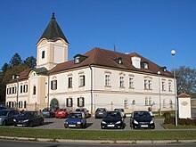
 Centre of Osek | |
| Coordinates: 49°19′6″N 13°57′48″E / 49.31833°N 13.96333°E | |
| Country | |
| Region | South Bohemian |
| District | Strakonice |
| First mentioned | 1392 |
| Area | |
| • Total | 13.92 km2 (5.37 sq mi) |
| Elevation | 450 m (1,480 ft) |
| Population (2024-01-01)[1] | |
| • Total | 647 |
| • Density | 46/km2 (120/sq mi) |
| Time zone | UTC+1 (CET) |
| • Summer (DST) | UTC+2 (CEST) |
| Postal code | 386 01 |
| Website | www |
Osek (German: Ossek) is a municipality and village in Strakonice District in the South Bohemian Region of the Czech Republic. It has about 600 inhabitants.
Administrative parts
[edit]The villages of Jemnice, Malá Turná, Petrovice and Rohozná are administrative parts of Osek.
Etymology
[edit]Osek is a common Czech toponymy. The word osek denotes a cut trunk and it also could mean a cut forest.[2]
Geography
[edit]Osek is located about 7 kilometres (4 mi) northeast of Strakonice and 52 km (32 mi) northwest of České Budějovice. It lies in the Blatná Uplands. The highest point is a hill at 506 m (1,660 ft) above sea level. There are several fishponds in the municipality; the largest of them are Velký and Bašta. The ponds are supplied by the stream Petrovický potok.
History
[edit]The first written mention of Osek is from 1392, then known as Vosek or Wossek. It was probably founded in the second half of the 14th century. The village began to grow around the lord's court, on which a fortress was probably built before 1414. Osek was acquired by King Wenceslaus IV as escheat. He divided it among his minions.[3]
Until World War I, the villages of Osek, Petrovice, Malá Turná and Rohozná were administrative parts of the municipality of Radomyšl, and Jemnice was a sovereign municipality. Shortly before World War I, the villages separated and created a new municipality. In 1924, Osek was renamed to its current name.[3] In 1961, Jemnice joined the Osek municipality.[4]
Demographics
[edit]
|
|
| ||||||||||||||||||||||||||||||||||||||||||||||||||||||
| Source: Censuses[5][6] | ||||||||||||||||||||||||||||||||||||||||||||||||||||||||
Transport
[edit]The I/4 road (the section from Strakonice to Příbram) passes through the municipality.
The railway line Strakonice–Blatná runs through the municipality, but there is no train station. The municipality is served by the station in neighbouring Radomyšl.
Sights
[edit]
The most important monument is the Osek Castle. The fortress from the 15th century was completely rebuilt into the current pseudo-Baroque castle in 1911. It has valuable interiors. Today it serves as a home for people with disabilities. Next to the castle is a park founded in the early 20th century.[7]
References
[edit]- ^ "Population of Municipalities – 1 January 2024". Czech Statistical Office. 2024-05-17.
- ^ Profous, Antonín (1951). Místní jména v Čechách III: M–Ř (in Czech). p. 289.
- ^ a b "Historie" (in Czech). Obec Osek. Retrieved 2021-08-23.
- ^ "Historický lexikon obcí České republiky - 1869–2011" (in Czech). Czech Statistical Office. p. 207. Retrieved 2021-08-23.
- ^ "Historický lexikon obcí České republiky 1869–2011" (in Czech). Czech Statistical Office. 2015-12-21.
- ^ "Population Census 2021: Population by sex". Public Database. Czech Statistical Office. 2021-03-27.
- ^ "Zámek" (in Czech). National Heritage Institute. Retrieved 2023-07-01.


 French
 Deutsch

