Paxton, Indiana
Paxton, Indiana | |
|---|---|
 | |
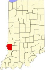
 Sullivan County's location in Indiana | |
| Coordinates: 39°01′16″N 87°23′19″W / 39.02111°N 87.38861°W | |
| Country | United States |
| State | Indiana |
| County | Sullivan |
| Township | Haddon |
| Elevation | 522 ft (159 m) |
| Time zone | UTC-5 (Eastern (EST)) |
| • Summer (DST) | UTC-4 (EDT) |
| ZIP code | 47865 |
| Area code(s) | 812, 930 |
| FIPS code | 18-58500[2] |
| GNIS feature ID | 449706 |
Paxton is an unincorporated community in Haddon Township, Sullivan County, in the U.S. state of Indiana.[3]
Paxton has nine cemeteries. Alsman Cemetery EST 1858 with 8 known memorials, Arnett Cemetery EST 1852 with twelve known memorials, Boone Cemetery EST 1816 with 53 known memorials, Loudermilk Cemetery EST 1853 with 3 known memorials, McCammon Cemetery EST Abt 1820 with 47 known memorials, McCammon Cemetery #1 EST 18?? With twenty known memorials, McClellan Snyder Cemetery EST 1821 with 238 known memorials, Neil-Paxton Cemetery EST 1821 with 225 known memorials, and the Providence Cemetery EST 1826 with 305 known memorials.
The community is part of the Terre Haute metropolitan area.
History
[edit]Paxton was laid out in 1868, and was named after James H. Paxton, a local merchant.[4] The post office at Paxton has been in operation since 1864.[5]
Geography
[edit]Paxton is located off Highway 41 between Carlisle and Sullivan at 39°01′16″N 87°23′19″W / 39.02111°N 87.38861°W.
References
[edit]- ^ "US Board on Geographic Names". United States Geological Survey. October 25, 2007. Retrieved January 31, 2008.
- ^ "U.S. Census website". United States Census Bureau. Retrieved January 31, 2008.
- ^ "Paxton, Indiana". Geographic Names Information System. United States Geological Survey. Retrieved August 5, 2017.
- ^ Baker, Ronald L. (October 1995). From Needmore to Prosperity: Hoosier Place Names in Folklore and History. Indiana University Press. p. 258. ISBN 978-0-253-32866-3.
...honors Dr. James H. Paxton, an early merchant and physician of Carlisle.
- ^ "Sullivan County". Jim Forte Postal History. Retrieved September 27, 2016.


 French
 Deutsch
