Route 200 (Israel)
| Route 200 | ||||
|---|---|---|---|---|
| כביש 200 | ||||
| Ramla bypass road | ||||
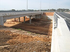
 Route 431 at the future West Ramla Interchange (January 2009) | ||||
| Route information | ||||
| Length | 3.27 km (2.03 mi) | |||
| Existed | 2020–present | |||
| Major junctions | ||||
| South end | West Ramla Interchange | |||
| North end | North Ramla Interchange | |||
| Location | ||||
| Country | Israel | |||
| Major cities | Ramla | |||
| Highway system | ||||
| ||||
Route 200 (also known as the Ramla bypass road) is a regional road in Israel that connects Highway 44 and Route 431. It mainly serves the residents of the western neighbourhoods of the city of Ramla and in the future also the Gani Aviv neighbourhood, located in the city of Lod and the neighbourhoods that will be built on the Tzrifin area.[1]
Part of the road was opened to traffic in May 2020.[2]
There are plans to extend the road to the Gani Aviv neighbourhood in Lod, but as of 2022, the plan has not been advanced.
Junctions (South to North)
[edit]| District[3] | Location[4] | km | mi | Name | Destinations | Notes |
|---|---|---|---|---|---|---|
| Central | Ramla | 0 | 0.0 | מחלף רמלה מערב (West Ramla Interchange) | ||
| 0.81 | 0.50 | צומת ללא שם (Unnamed Junction) | Moshe Arens Boulevard | |||
| 1.45 | 0.90 | צומת ללא שם (Unnamed Junction) | Moshe Levi Street | |||
| 1.67 | 1.04 | צומת ללא שם (Unnamed Junction) | Ze'ev Jabotinsky Street | |||
| 1.94 | 1.21 | צומת ללא שם (Unnamed Junction) | Moshe Dayan Street | |||
| 3.27 | 2.03 | מחלף רמלה צפון (North Ramla Interchange) | ||||
| 1.000 mi = 1.609 km; 1.000 km = 0.621 mi | ||||||
References
[edit]- ^ אלון גרינברג (June 2, 2017). "ערים מתרחבות: השכונות החדשות של ישראל". Ynet.
- ^ "Ramla city center renewal plan approved". Globes. January 27, 2020.
- ^ Survey of Israel (October 31, 2018). "מחוזות משרד הפנים" [Ministry of Interior districts] (Map). Govmap (in Hebrew). Retrieved October 31, 2018.
- ^ Survey of Israel (October 31, 2018). "גבולות ישובים" [Locality borders] (Map). Govmap (in Hebrew). Retrieved October 31, 2018.


 French
 Deutsch
