Takapoto
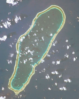
 NASA picture of Takapoto Atoll | |
| Geography | |
|---|---|
| Location | Pacific Ocean |
| Coordinates | 14°37′39″S 145°12′18″W / 14.62750°S 145.20500°W |
| Archipelago | Tuamotus |
| Area | 85 km2 (33 sq mi) (lagoon) 15 km2 (6 sq mi) (above water) |
| Length | 20 km (12 mi) |
| Width | 6.7 km (4.16 mi) |
| Administration | |
France | |
| Overseas collectivity | French Polynesia |
| Administrative subdivision | Tuamotus |
| Commune | Takaroa |
| Largest settlement | Fakatopatere |
| Demographics | |
| Population | 380[1] (2012) |
Takapoto, Tua-poto or Oura, is an atoll in the Tuamotu group in French Polynesia. It has a length of 20 kilometres (12 miles) and a width of 6.7 kilometres (4.2 miles).
The nearest land is Takaroa Atoll, located 10 kilometres (6 miles) to the northeast.
Takapoto's lagoon has a high salinity and a strong phytoplankton biomass.
Geographically Takapoto is part of the King George Islands (Iles du Roi Georges) subgroup, which includes: Ahe, Manihi, Takapoto, Takaroa and Tikei.
Takapoto Atoll has 380 inhabitants. Fakatopatere, the main village on Takapoto, is located at the southern end of the atoll.
History
[edit]The first recorded European to sight Takapoto Atoll was Jacob Le Maire in 1616.[2]
Takapoto Atoll was visited by the Charles Wilkes expedition in September 1839.
Takapoto Airport was inaugurated in 1973.
Administration
[edit]The commune of Takaroa-Takapoto consists of the atolls of Takaroa and Takapoto, and Tikei Island.
See also
[edit]References
[edit]- ^ "Population". Institut de la statistique de la Polynésie française. Retrieved 20 October 2014.
- ^ Sample Chapter(s) for Historical%2 Archived 2011-05-22 at the Wayback Machine
External links
[edit]


 French
 Deutsch