
 French
 Deutsch
Staintondale
| Civil parish in Engeland | |||
|---|---|---|---|
.svg) | |||
| Situering | |||
| Regio | Yorkshire and the Humber | ||
| Graafschap | North Yorkshire | ||
| District | Scarborough | ||
| Coördinaten | 54° 22' NB, 0° 29' WL | ||
| Algemeen | |||
| Oppervlakte | 12,8756 km² | ||
| Inwoners (2011) | 341 (26 inw./km²) | ||
| Overig | |||
| Postcode(s) | YO13 | ||
| Grid code | SE990985 | ||
| Post town | SCARBOROUGH | ||
| ONS-code | E04007701 | ||
| |||
Staintondale, ook Stainton Dale, is een civil parish in het bestuurlijke gebied Scarborough, in het Engelse graafschap North Yorkshire met 341 inwoners.
-
 Village Hall
 -
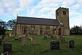 Kerk van St John the Baptist

.jpg)
Geplaatst op:
4-8-2010
4-8-2010
Dit artikel is een beginnetje over landen & volken. U wordt uitgenodigd om op bewerken te klikken om uw kennis aan dit artikel toe te voegen.