
 French
 Deutsch
Fișier:Census Regions and Divisions.PNG
Mărimea acestei previzualizări: 788 × 600 pixeli. Alte rezoluții: 315 × 240 pixeli | 631 × 480 pixeli | 909 × 692 pixeli.
Mărește rezoluția imaginii (909 × 692 pixeli, mărime fișier: 92 KB, tip MIME: image/png)
| Acest fișier se află la Wikimedia Commons. Consultați pagina sa descriptivă acolo. |
Descriere fișier
 | This map has been uploaded by Electionworld from en.wikipedia.org to enable the |
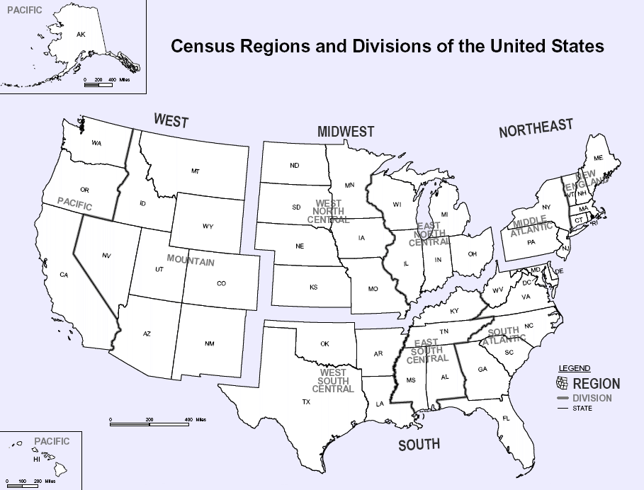
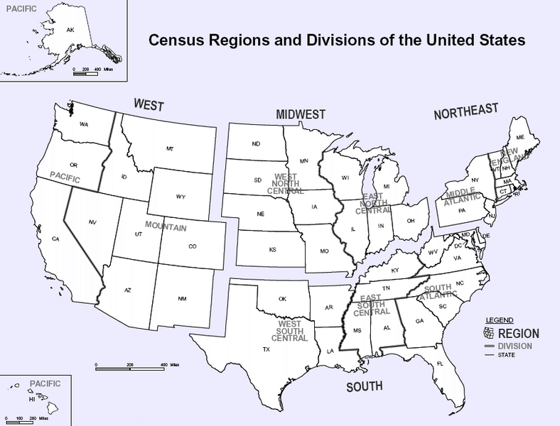
Map of U.S. Census Regions and Divisions. This map shows the four official US Census Regions, and the nine official Divisions within those Regions. See also: Image:US Census regional map.gif.
Licențiere
This work is in the public domain in the United States because it is a work prepared by an officer or employee of the United States Government as part of that person’s official duties under the terms of Title 17, Chapter 1, Section 105 of the US Code. Note: This only applies to original works of the Federal Government and not to the work of any individual U.S. state, territory, commonwealth, county, municipality, or any other subdivision. This template also does not apply to postage stamp designs published by the United States Postal Service since 1978. (See § 313.6(C)(1) of Compendium of U.S. Copyright Office Practices). It also does not apply to certain US coins; see The US Mint Terms of Use. |  | |
| Acest fișier a fost identificat ca fiind liber de orice restricții cunoscute privind legea drepturilor de autor, inclusiv toate drepturile conexe sau înrudite. | ||
 | O versiune vectorială a acestei imagini (SVG) este disponibilă. Aceasta ar trebui folosită în locul vechii imagini pentru o afișare mai bună la rezoluții mari. File:Census Regions and Divisions.PNG → File:Census Regions and Division of the United States.svg Pentru mai multe informații despre imaginile vectoriale, consultați pagina Commons transition to SVG. Vedeți, de asemenea, și informațiile despre modul în care software-ul MediaWiki acceptă imagini în format SVG. |  |
Istoricul fișierului
Apăsați pe Data și ora pentru a vedea versiunea trimisă atunci.
| Data și ora | Miniatură | Dimensiuni | Utilizator | Comentariu | |
|---|---|---|---|---|---|
| actuală | 9 noiembrie 2023 14:56 | | 909x692 (92 KB) | Harold | Reverted to version as of 19:46, 13 June 2010 (UTC), COM:OW |
| 4 septembrie 2020 01:08 |  | 2.200x1.700 (103 KB) | ACupOfCoffee | Census regions were changed in 2013. | |
| 13 iunie 2010 22:46 |  | 909x692 (92 KB) | Ras67 | cropped, wm removed | |
| 30 noiembrie 2006 01:11 |  | 916x699 (107 KB) | Electionworld | {{ew|en|NThurston}} Map of U.S. Census Regions and Divisions. == Licensing == {{PD-USGov}} Category:Maps of the United States |
Utilizarea fișierului
Următoarele pagini conțin această imagine:
Utilizarea globală a fișierului
Următoarele alte proiecte wiki folosesc acest fișier:
- Utilizare la bn.wikipedia.org
- Utilizare la ca.wikipedia.org
- Utilizare la de.wikipedia.org
- Utilizare la en.wikipedia.org
- Utilizare la eo.wikipedia.org
- Utilizare la gl.wikipedia.org
- Utilizare la it.wikipedia.org
- Utilizare la ja.wikipedia.org
- Utilizare la ko.wikipedia.org
- Utilizare la nn.wikipedia.org
- Utilizare la simple.wikipedia.org
- Utilizare la sk.wikipedia.org
- Utilizare la tr.wikipedia.org
- Utilizare la vec.wikipedia.org
- Utilizare la vi.wikipedia.org