Midi-Pyrénées - Simple English Wikipedia, the free encyclopedia
Midi-Pyrénées | |
|---|---|
 | |
| Country | |
| Dissolved | 1 January 2016 |
| Prefecture | Toulouse |
| Departments | |
| Government | |
| • President | Martin Malvy (PS) |
| Area | |
| • Total | 45,348 km2 (17,509 sq mi) |
| Population (1 January 2012) | |
| • Total | 2,926,592 |
| • Density | 65/km2 (170/sq mi) |
| Time zone | UTC+1 (CET) |
| • Summer (DST) | UTC+2 (CEST) |
| ISO 3166 code | FR-N |
| GDP (2012)[1] | Ranked 8th |
| Total | €79.9 billion (US$102.7 bn) |
| Per capita | €27,198 (US$34,982) |
| NUTS Region | FR6 |
| Website | Midi-Pyrenees Region |
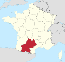
Midi-Pyrénées (Occitan: Miègjorn-Pirenèus or Mieidia-Pirenèus) is a former administrative region of France. It is now part of the administrative region of Occitanie. It is part of the historical region of Occitania.
The name of the region is not based on any old name, like in most other regions, but on the geography of the region, Midi (meaning "southern France") - Pyrénées (Pyrenees mountains that are the highest mountains in the region). The French adjective and name of the people living in the region is Midi-Pyrénéen.
The departments in the region were Ariège, Aveyron, Haute-Garonne, Gers, Lot, Hautes-Pyrénées, Tarn, and Tarn-et-Garonne. Its capital was Toulouse.
Geography
[change | change source]The Midi-Pyrénées region is the largest region of Metropolitan France. It had an area of 45,348 km2 (17,509 sq mi).[2] It bordered to the south with Spain and Andorra. It also bordered four French regions: Aquitaine to the west, Limousin to the north, Auvergne to the northeast and Languedoc-Roussillon to the east.
The region can be divided into three landscape zones:
- The south is dominated by the high mountains of the Pyrenees.
- The north-east and the north are part of the highlands of the Massif Central
- The central and north-western parts of the region, however, are flat. This zone is dominated by the Garonne river and its tributaries, which drains most of the region to the Atlantic Ocean.
The Pic Vignemale (42°46′26″N 0°8′51″E / 42.77389°N 0.14750°E), at 3,299 m (10,823 ft), is the highest point of the Midi-Pyrénées region; it is on the border with Spain.[3] The Vignemale is in the Pyrénées National Park.
The main rivers of the region are the Garonne river, that flows through the Haute-Garonne, Hautes-Pyrénées and Tarn-et-Garonne departments;[4] and the Adour river, that flows through the Hautes-Pyrénées and Gers departments.[5]
Departments
[change | change source]The Midi-Pyrénées region was formed by eight departments:
| Département | Préfecture | ISO 3166-2 | Population (2012)[6] | Area (km²) | Density (Inh./km²) |
|---|---|---|---|---|---|
| Ariège | Foix | FR-09 | 152,366 | 4,890 | 31.2 |
| Aveyron | Rodez | FR-12 | 276,229 | 8,735 | 31.6 |
| Haute-Garonne | Toulouse | FR-31 | 1,279,349 | 6,309 | 202.8 |
| Gers | Auch | FR-32 | 189,530 | 6,257 | 30.3 |
| Lot | Cahors | FR-46 | 174,346 | 5,217 | 33.4 |
| Hautes-Pyrénées | Tarbes | FR-65 | 228,854 | 4,464 | 51.3 |
| Tarn | Albi | FR-81 | 378,947 | 5,758 | 65.8 |
| Tarn-et-Garonne | Montauban | FR-82 | 246,971 | 3,718 | 66.4 |
Demographics
[change | change source]In 2012, The Midi-Pyrénées region had a population of 2,926,592.[7] Its population density was 64.5 inhabitants/km2.

The 10 most important cities in the region were:
| City | Population (2012)[6] | Départment |
|---|---|---|
| Toulouse | 453,317 | Haute-Garonne |
| Montauban | 56,887 | Tarn-et-Garonne |
| Albi | 49,231 | Tarn |
| Tarbes | 41,664 | Hautes-Pyrénées |
| Castres | 41,529 | Tarn |
| Colomiers | 36,699 | Haute-Garonne |
| Tournefeuille | 26,342 | Haute-Garonne |
| Muret | 24,492 | Haute-Garonne |
| Rodez | 23,744 | Aveyron |
| Blagnac | 22,983 | Haute-Garonne |
Gallery
[change | change source]- Massif of Tabe, Ariège
- Sunflowers in Gers
- Salat river, Haute-Garonne
- Middle Lake of Bastan, Hautes-Pyrénées
- Lot river in Lot
References
[change | change source]- ↑ INSEE. "Produits intérieurs bruts régionaux et valeurs ajoutées régionales de 1990 à 2012". Retrieved 2014-03-04.
- ↑ "Grands repères" (in French). Région Midi-Pyrénées. Archived from the original on 17 March 2015. Retrieved 10 February 2015.
- ↑ "Pic Vignemale, France/Spain". Peakbagger.com. Retrieved 15 April 2014.
- ↑ "La Garonne (O---0000))" (in French). SANDRE - Portail national d'accès aux référentiels sur l'eau. Archived from the original on 3 March 2016. Retrieved 15 April 2014.
- ↑ "L'Adour (Q---0000)" (in French). SANDRE - Portail national d'accès aux référentiels sur l'eau. Archived from the original on 27 May 2015. Retrieved 15 April 2014.
- ↑ 6.0 6.1 "Populations légales 2012 des départements et des collectivités d'outre-mer" (in French). Institut national de la statistique et des études économiques - INSEE. Retrieved 10 February 2015.
- ↑ "Populations légales 2012 des régions" (in French). Institut national de la statistique et des études économiques - INSEE. Retrieved 10 February 2015.
Other websites
[change | change source]- Regional Council of Midi-Pyrénées official website Archived 2011-09-13 at the Wayback Machine (in French)
- france.fr - Official website of France (in French)
- About-France.com: MIDI-PYRENEES - a short guide


 French
 Deutsch


