Mount Roraima - Simple English Wikipedia, the free encyclopedia
| Mount Roraima | |
|---|---|
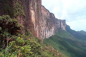
 Mt. Roraima during the wet season | |
| Highest point | |
| Elevation | 2,810 m (9,220 ft) |
| Prominence | 2,338 m (7,671 ft) |
| Listing | Country high point Ultra prominent peak |
| Coordinates | 5°08′36″N 60°45′45″W / 5.14333°N 60.76250°W |
| Geography | |
| Location | Venezuela/Brazil/ |
| Country | |
| Geology | |
| Mountain type | Plateau |
| Climbing | |
| First ascent | 1884 |
| Easiest route | Hike |
Mount Roraima is the highest of the Pakaraima chain of plateaus in South America.[1]
It was first described to Europeans by the English explorer Sir Walter Raleigh during his 1595 expedition. Raleigh learned about it from indigenous peoples.
Roraima has a 31-square-kilometre (12-square-mile) summit area.[1]: 156 It is bounded on all sides by cliffs rising 400 metres (1,300 ft).
The mountain is in Venezuela and Brazil.[1] Mount Roraima is the point where the boundaries of Venezuela and Brazil. A stone stands on its summit, put there by the International Commission in 1931.
Mount Roraima lies on the Guiana Shield. It is the highest point of the Brazilian state of Roraima lie on the plateau, but Venezuela and Brazil have higher mountains elsewhere. The triple border point is at 5°12′08″N 60°44′07″W / 5.20222°N 60.73528°W, and the mountain's highest point is called 'Laberintos del Norte'.

Although the steep sides of the plateau make it difficult, it was the first recorded major table-top to be climbed. Sir Everard im Thurn walked up a forested ramp on 18 December 1884 to scale the plateau. This route also used by the Clementis group in their climb of 15 January 1916.[2]: 463 It is one of the most important mountain trekking routes in Venezuela.
References
[change | change source]- ↑ 1.0 1.1 1.2 Swan, Michael (1957), British Guiana, London, England, U.K.: Her Majesty's Stationery Office, OCLC 253238145
- ↑ Clementi, Mrs Cecil (1916). "A Journey to the Summit of Mt Roraima". The Geographical Journal. 48 (6): 456–473. doi:10.2307/1779816. JSTOR 1779816.


 French
 Deutsch