Popocatépetl - Simple English Wikipedia, the free encyclopedia
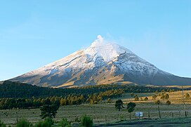
Popocatépetl (also called El popo or Don Goyo) is an active volcano.[1] The volcano is the second highest mountain in Mexico after Pico de Orizaba (5,610m). It is 5,426 m (17,802 ft) high .
| Popocatépetl | |
|---|---|
 Popocatépetl, viewed from the north from Paso de Cortés. | |
| Highest point | |
| Elevation | 5,426 m (17,802 ft)[a] |
| Prominence | 3,020 m (9,910 ft)[3][4] |
| Isolation | 143 km (89 mi) |
| Listing | |
| Coordinates | 19°01′20″N 98°37′40″W / 19.02222°N 98.62778°W |
| Geography | |
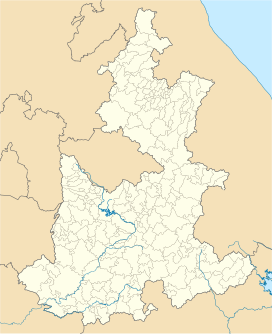
| Location | Mexico-Puebla-Morelos, Mexico |
| Geology | |
| Mountain type | Stratovolcano |
| Last eruption | 2004 to 2022 (ongoing)[5] |
| Climbing | |
| Easiest route | rock/snow climb |
History
[change | change source]Popocatépetl is the Aztec word for "Smoking Mountain". Popocatépetl was an Aztec warrior who loved Iztaccíhuatl. Iztaccíhuatl's father sent Popocatepetl to war in Oaxaca. He promised him his daughter as his wife if he returned (which Iztaccíhuatl's father thought he would not). Iztaccíhuatl's father told her that her lover had died in battle. She died of sadness. When Popocatépetl returned, and found out about the death of his lover, he killed himself by stabbing a knife into his heart. The gods covered them with snow and changed them into mountains. Iztaccíhuatl's mountain was called "La Mujer Dormida, (the "Sleeping Woman"), because it looks like a woman sleeping on her back. Popocatépetl became the volcano Popocatépetl, raining fire on Earth in anger at the loss of his lover.
Eruptions
[change | change source]Popocatepetl has had more than 20 big eruptions since the arrival of the Spanish in 1519. A major eruption happened in 1947. On December 21, 1994 the volcano threw out gas and ash which was carried as far as 25 km away by the wind. This led to people having to leave nearby towns. Scientists began to check the volcano for an eruption.The way scientists checked the volcano was by implementing 10 composite monitoring stations around the volcano, including broadband seismometers, thermal surveillance cameras, tiltmeters, electronic distance meters, lahar acoustic detectors and other instruments. In December 2000, tens of thousands of people were made to leave the area by the government based on the warnings of scientists. The volcano then made its largest display in thousands of years. The most recent eruption which was this year didn't have any injuries. Since it was so near Mexico City so many cameras were recording this eruption. Officials recorded that the eruption had a column of smoke that went as high as 2 miles into the air, with moderate ash content.
Related pages
[change | change source]Notes
[change | change source]References
[change | change source]- ↑ Rosenberg, Matt. "Pacific Ring of Fire," Archived 2010-12-04 at the Wayback Machine About.com; retrieved 2012-6-15.
- ↑ "Popocatépetl". Global Volcanism Program. Smithsonian Institution.
- ↑ "Mexico Ultras". Peaklist.org. Retrieved 2012-01-29. The prominence value given here of 3,020 m (9,910 ft) is based on a summit elevation of 5,400 m (17,700 ft) for Popocatépetl.
- ↑ "Volcán Popocatépetl, Mexico". Peakbagger.com. Retrieved 2012-01-29. The prominence value given here of 3,020 m (9,910 ft) is interpolated from a summit elevation of 5,400 m (17,700 ft) for Popocatépetl.
- ↑ "Popocatépetl volcano". 19 Feb 2018.
- De la Cruz-Reyna, Servando, et al. “Tectonic Earthquakes Triggering Volcanic Seismicity and Eruptions. Case Studies at Tungurahua and Popocatépetl Volcanoes.” Journal of Volcanology and Geothermal Research, vol. 193, no. 1, 2010, pp. 37–48.
- https://earthsky.org/earth/volcano-popocatepetl-eruption-mexico-jan-9-2020
Other websites
[change | change source]![]() Media related to Popocatépetl at Wikimedia Commons
Media related to Popocatépetl at Wikimedia Commons


 French
 Deutsch

