Richland County, South Carolina - Simple English Wikipedia, the free encyclopedia
Richland County | |
|---|---|
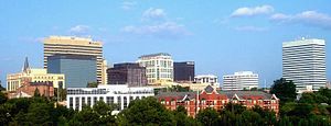
 Skyline of Columbia | |
| Motto: "Uniquely Urban...Uniquely Rural" | |
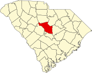
 Location within the U.S. state of South Carolina | |
 South Carolina's location within the U.S. | |
| Coordinates: 34°01′45″N 80°53′53″W / 34.029095°N 80.898037°W | |
| Country | |
| State | |
| Founded | March 12, 1785 |
| Named for | The county's "rich land"[1] |
| Seat | Columbia |
| Largest community | Columbia |
| Area | |
| • Total | 771.96 sq mi (1,999.4 km2) |
| • Land | 757.28 sq mi (1,961.3 km2) |
| • Water | 14.68 sq mi (38.0 km2) 1.90% |
| Population (2020) | |
| • Total | 416,147 |
| • Density | 549.53/sq mi (212.17/km2) |
| Time zone | UTC−5 (Eastern) |
| • Summer (DST) | UTC−4 (EDT) |
| Congressional districts | 2nd, 6th |
| Website | www |
Richland County is a county in the U.S. state of South Carolina. As of the 2020 census, 416,147 people lived there,[2] making it the second-most populous county in South Carolina, after Greenville County. The county seat and largest city is Columbia,[3] the state capital. The county was created in 1785.
References
[change | change source]- ↑ "About Richland County". www.richlandcountysc.gov. Retrieved June 13, 2022.
- ↑ "QuickFacts: Richland County, South Carolina". United States Census Bureau. Retrieved January 20, 2024.
- ↑ National Association of Counties. "NACo County Explorer". Retrieved January 20, 2024.
Other websites
[change | change source]Wikimedia Commons has media related to Richland County, South Carolina.


 French
 Deutsch