Nipissing District – Wikipedia
| Nipissing District | |
| Distrikt | |
| Land | |
|---|---|
| Provins | Ontario |
| Koordinater | 46°13′N 79°2′V / 46.217°N 79.033°V |
| Area | 17 103,78 km²[1] |
| Folkmängd | 83 150 (2016)[1] |
| Befolkningstäthet | 4,9 invånare/km² |
| Tidszon | EST (UTC-5) |
| - sommartid | EDT (UTC-4) |
| Geonames | 6088501 |
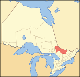
| Nipissings läge i Ontario. | |
Nipissing District är ett distrikt i provinsen Ontario i Kanada.[2] Det ligger i östra delen av provinsen.
Kommuner
[redigera | redigera wikitext]I distriktet finns följande kommuner:
| Kommun | Kommuntyp |
|---|---|
| North Bay | City |
| Mattawa | Town |
| Bonfield | Township |
| Chisholm | Township |
| Mattawan | Township |
| Papineau-Cameron | Township |
| South Algonquin | Township |
| Calvin | Municipality |
| East Ferris | Municipality |
| Temagami | Municipality |
| West Nipissing | Municipality |
Dessutom finns de två indianreservaten Nipissing 10 och Bear Island 1.
Källor
[redigera | redigera wikitext]- ^ [a b] Profil du recensement, Recensement de 2016, Statistique Canada. Läst 24 december 2017.
- ^ Place names - Nipissing, Natural Resources Canada. Läst 24 december 2017.


 French
 Deutsch