Файл:Map of Jupiter.jpg — Вікіпедія

Розмір при попередньому перегляді: 590 × 599 пікселів. Інші роздільності: 236 × 240 пікселів | 473 × 480 пікселів | 756 × 768 пікселів | 1008 × 1024 пікселів | 2231 × 2266 пікселів.
Повна роздільність (2231 × 2266 пікселів, розмір файлу: 426 КБ, MIME-тип: image/jpeg)
Історія файлу
Клацніть на дату/час, щоб переглянути, як тоді виглядав файл.
| Дата/час | Мініатюра | Розмір об'єкта | Користувач | Коментар | |
|---|---|---|---|---|---|
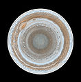
| поточний | 10:59, 14 лютого 2007 |  | 2231 × 2266 (426 КБ) | Helix84 | {{en| :This map of Jupiter is the most detailed global color map of the planet ever produced. The round map is a polar stereographic projection that shows the south pole in the center of the map and the equator at the edge. It was constructed from images |
Використання файлу
Такі сторінки використовують цей файл:
Глобальне використання файлу
Цей файл використовують такі інші вікі:
- Використання в af.wikipedia.org
- Використання в ar.wikipedia.org
- Використання в bn.wikipedia.org
- Використання в ca.wikipedia.org
- Використання в de.wikipedia.org
- Використання в en.wikipedia.org
- Jupiter
- Wikipedia:Featured pictures thumbs/05
- Wikipedia:Featured picture candidates/October-2006
- Wikipedia:Featured picture candidates/Map of Jupiter
- User:Andonic/Successful Featured Picture Nominations
- Wikipedia:Featured picture candidates/January-2007
- Wikipedia:Featured picture candidates/Polar Map of Jupiter
- Wikipedia:Wikipedia Signpost/2007-01-15/Features and admins
- Wikipedia:Wikipedia Signpost/2007-01-15/SPV
- User talk:Andonic/Archive 7
- Wikipedia:WikiProject Astronomy/Recognized content
- Portal:Solar System/Selected article
- Portal:Solar System/Selected picture
- Wikipedia:Picture of the day/May 2007
- Template:POTD/2007-05-10
- User talk:Andonic/Archive 11
- Portal:Solar System/Selected picture/11
- Wikipedia:Featured pictures/Space/Looking out
- Wikipedia:Today's featured article/August 2009
- Wikipedia:Today's featured article/August 25, 2009
- Portal:Solar System/Selected article/21
- Talk:Jupiter/Archive 5
- Atmosphere of Jupiter
- Wikipedia:WikiProject Astronomy/Recognized astronomy content
- Wikipedia:Wikipedia Signpost/Single/2007-01-15
- Використання в es.wikipedia.org
- Використання в eu.wikipedia.org
- Використання в fr.wikipedia.org
- Використання в it.wikipedia.org
- Використання в ja.wikipedia.org
- Використання в kn.wikipedia.org
- Використання в la.wikipedia.org
- Використання в mk.wikipedia.org
- Використання в nds.wikipedia.org
Переглянути сторінку глобального використання цього файлу.


 French
 Deutsch


