File:Cities of Tierra del Fuego.png - 维基百科,自由的百科全书
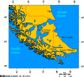
Cities_of_Tierra_del_Fuego.png (519 × 475像素,文件大小:21 KB,MIME类型:image/png)
文件历史
点击某个日期/时间查看对应时刻的文件。
| 日期/时间 | 缩略图 | 大小 | 用户 | 备注 | |
|---|---|---|---|---|---|
| 当前 | 2005年10月6日 (四) 11:47 |  | 519 × 475(21 KB) | ChongDae | This image was copied from wikipedia:en. The original description was: Cities of Tierra del Fuego {{GFDL}} This map was created with this [http://www.aquarius.geomar.de/omc/ online map creation tool]. The longitude and latitude of the cities follow: *- |
| 2005年4月24日 (日) 10:46 |  | 519 × 475(21 KB) | Poulpy | Cities of Tierra del Fuego {{GFDL}} This map is taken from en:Image:Cities of Tierra del Fuego.png and was created with this [http://www.aquarius.geomar.de/omc/ online map creation tool]. The longitude and latitude of the cities follow: *-70.9333,- |
文件用途
以下页面使用本文件:
全域文件用途
以下其他wiki使用此文件:
- ar.wikipedia.org上的用途
- bg.wikipedia.org上的用途
- ca.wikipedia.org上的用途
- ckb.wikipedia.org上的用途
- cs.wikipedia.org上的用途
- da.wikipedia.org上的用途
- de.wikipedia.org上的用途
- el.wikipedia.org上的用途
- en.wikipedia.org上的用途
- eo.wikipedia.org上的用途
- es.wikipedia.org上的用途
- fa.wikipedia.org上的用途
- fr.wikipedia.org上的用途
- fy.wikipedia.org上的用途
- gd.wikipedia.org上的用途
- hr.wikipedia.org上的用途
- id.wikipedia.org上的用途
- it.wikipedia.org上的用途
- ja.wikipedia.org上的用途
- ka.wikipedia.org上的用途
- ko.wikipedia.org上的用途
- la.wikipedia.org上的用途
- lt.wikipedia.org上的用途
- mk.wikipedia.org上的用途
- ml.wikipedia.org上的用途
- nl.wikipedia.org上的用途
- no.wikipedia.org上的用途
- pl.wikipedia.org上的用途
- pl.wiktionary.org上的用途
- pt.wikipedia.org上的用途
- ro.wikipedia.org上的用途
查看此文件的更多全域用途。


 French
 Deutsch

