
 French
 Deutsch
File:Rear map.jpg - 维基百科,自由的百科全书

本预览的尺寸:800 × 588像素。 其他分辨率:320 × 235像素 | 640 × 470像素 | 1,024 × 752像素 | 1,280 × 940像素 | 2,201 × 1,617像素。
原始文件 (2,201 × 1,617像素,文件大小:1.61 MB,MIME类型:image/jpeg)
摘要
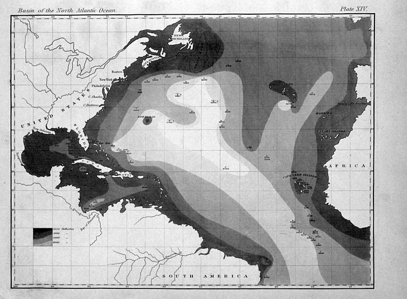
| 描述 | English: "The very earliest rendition of a bathymetric map of an oceanic basin. Matthew Fontaine Maury published this map in 1853 in Explanations and Sailing Directions to Accompany the Wind and Current Charts." |
| 日期 | |
| 来源 | http://oceanexplorer.noaa.gov/history/readings/vicissitudes/media/gulf.html |
| 作者 | Matthew Fontaine Maury |
许可协议
本图像属于公有领域,因该作品最初来自于美国国家海洋和大气管理局职员的职务作品。
|
| 本作品在其来源国以及其他著作权期限是作者逝世后70年或以下的国家和地区属于公有领域。 | |
| 本文件已被确认为免除已知的著作权法限制(包括所有相关权利)。 | |
文件历史
点击某个日期/时间查看对应时刻的文件。
| 日期/时间 | 缩略图 | 大小 | 用户 | 备注 | |
|---|---|---|---|---|---|
| 当前 | 2011年8月6日 (六) 16:31 | | 2,201 × 1,617(1.61 MB) | Belg4mit | {{Information |Description ={{en|1="The very earliest rendition of a bathymetric map of an oceanic basin. Matthew Fontaine Maury published this map in 1853 in ''Explanations and Sailing Directions to Accompany the Wind and Current Charts''."}} |Sou |
文件用途
以下页面使用本文件:
全域文件用途
以下其他wiki使用此文件:
- bg.wikipedia.org上的用途
- en.wikipedia.org上的用途
- eo.wikipedia.org上的用途
- fa.wikipedia.org上的用途
- fr.wikipedia.org上的用途
- mk.wikipedia.org上的用途
- pt.wikipedia.org上的用途
- tr.wikipedia.org上的用途