
 French
 Deutsch
Chibcha Terrane
| Chibcha Terrane | |
|---|---|
| Stratigraphic range: Meso-Neoproterozoic ~ | |
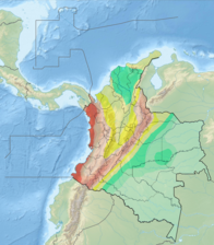
 Chibcha Terrane is enclosed by the Bucaramanga-Santa Marta Fault (orange), northernmost Oca Fault (white), Eastern Frontal Fault System (yellow) and Romeral Fault System (violet) | |
| Type | Terrane |
| Unit of | North Andes Plate |
| Sub-units | Subunits |
| Underlies | Tahamí & La Guajira Terranes |
| Overlies | Río Negro-Juruena Province |
| Lithology | |
| Primary | Complexes, basins |
| Other | Volcanoes |
| Location | |
| Location | Antioquia, Arauca, Bogotá, Bolívar, Boyacá, Caquetá, Casanare, Cesar, Cundinamarca, Huila, Magdalena, Meta, Putumayo, Norte de Santander, Santander, Tolima departments |
| Coordinates | 4°43′22.4″N 74°04′23.7″W / 4.722889°N 74.073250°W |
| Region | Andean |
| Country | |
| Extent | Central, Eastern, Perijá, SNSM, San Lucas, La Macarena |
| Type section | |
| Named for | Chibcha |
 Chibcha Terrane (Colombia)  Chibcha Terrane (Bogotá) | |
The Chibcha Terrane (Spanish: Terreno Chibcha, TCH), named after Chibcha, is the largest of the geological provinces (terranes) of Colombia. The terrane, the oldest explored domains of which date to the Meso- to Neoproterozoic, is situated on the North Andes Plate. The megaregional Romeral Fault System forms the contact of the terrane with the Tahamí Terrane.[1] The contact with the Caribbean and La Guajira Terranes is formed by the regional Bucaramanga-Santa Marta Fault.[2] The northeastern boundary is formed by the regional Oca Fault, bounding the La Guajira Terrane.[3] The terrane is emplaced over the Río Negro-Juruena Province of the Amazonian Craton along the megaregional Eastern Frontal Fault System.[4][5]

Geological Terranes Map of Colombia. Terrane abbreviation is in parentheses in the legend, followed by a hyphen and age notation. K1: Early Cretaceous, T: Triassic, P: Permian, D: Devonian, C1: Mississippian, MP: Mesoproterozoic, NP: Neoproterozoic, and PP: Paleoproterozoic.
Reinterpretation[edit]
A study performed by Mora Bohórquez et al. in 2017 showed no basement variation between the San Lucas basement underlying the Lower Magdalena Valley (VIM) and the SNSM basement to the east of the Santa Marta Fault. The authors redefined the contacts between the different terranes, using the names Calima Terrane for the coastal portion of the Caribbean Terrane (San Jacinto and Sinú foldbelts) and Tahamí-Panzenú Terrane for the Tahamí Terrane.[6]
Subdivision[edit]
_-_Carta_XVII_-_Geolog%C3%ADa_de_Colombia,_Venezuela_y_Ecuador.jpg)
(Codazzi, 1890)


Some authors consider the Garzón Complex a separate terrane; the Andaquí Terrane.[7][8][9]
Complexes[edit]
- SNSM - Early Eocene
- Santa Marta Batholith
- San Lorenzo
- Socorro
- Bolívar
- Aracataca
- Los Clavos
- Central Batholith
- Río Sevilla
- Latal
- San Lorenzo
- San Pedro de la Sierra
- Río Oríhueca
- Golero
- Los Tábanos
- Atánquez
- Nueva Lucha
- La Piña
- La Caja de Ahorros
- La Paila
- Buritacá
- SNSM Paleozoic
- Los Indios-Corual - Lopingian[10]
- Chundúa - Carboniferous (~Moscovian) to Permian (Guadalupian)[10]
- Los Mangos - basement[10]
- Dibuya - Mesoproterozoic (1000 Ma)[11]
- Sierra Nevada de Santa Marta (La Guajira Terrane)
- Palmarito - Cisuralian-Guadalupian[12]
- Manaure - Moscovian-Gzhelian[12]
- Río Cachirí
- La Virgen[13] or Guaca - Silurian (Ludlow)[10]
- Perjiá Series - Neoproterozoic basement[10]
- Santander - Neoproterozoic-Ordovician
- Tiburón - Lopingian[10]
- Diamante - Artinskian-Guadalupian[12]
- Río Chitagá - Givetian[10]
- San Pedro (formerly 'Silgará Formation')[14]
- Chicamocha (idem)[14]
- Pescadero
- La Corcova
- Bucamanga - basement[10][15]
- Floresta - Cambro-Ordovician
- Chuscales[16]
- Otengá[16]
- Santa Rosita[16]
- Buntia
- Chuscales Phyllite
- Busbanzá[16]
- Neoproterozoic 'Nickerian basement[10]
- Farallones - Carboniferous-Devonian[18]
- Guatiquía - Carboniferous (~Gzhelian) to Permian (Guadalupian)[10]
- Clarín-Guacavia - Carboniferous (~Moscovian to Kasimovian)
- Gutiérrez - Eifelian-Givetian[10]
- Puente Quetame, La Balsa - Silurian (Ludlow)[10]
- Quetame Group - Cambro-Ordovician[10]
- Neoproterozoic unnamed basement[10]
- Sombrerillo Quartzmonzodiorite
- Sombrerillo Porphyrics
- Altamira
- Mazamorras
- La Macarena - Mesoproterozoic
- San Lucas - Cambrian
- La Cocha-Río Tellez
- Norosí
- Bolívar
- Segovia
- Icarco
- La Magdalena
- San Lucas
- Puente Linda
- El Morro
- La Miel
- Norcasía
- El Hatillo
- Southwestern Chibcha
Andaquí Terrane[edit]
- Garzón - Neoproterozoic
Volcanoes[edit]
Ranges[edit]
Basins[edit]
- Catatumbo
- Cesar-Ranchería[22][23]
- Eastern Cordillera
- Middle Magdalena (VMM)[24][25]
- Upper Magdalena (VSM)
Faults[edit]
bounding faults in bold
- Bucaramanga-Santa Marta (BSF)[2]
- Eastern Frontal (EFS)[4]
- Oca[3]
- Otú Norte[26]
- La Palestina (LPF)[27]
- Romeral (RFS)[1]
- Bagre Norte[26]
- Bituima-La Salina
- Bogotá[28]
- Caño Tomás[29]
- Chitagá-Pamplona[30]
- Cimitarra[31]
- Cucuana[32]
- La Dina[33]
- Honda[34]
- Ibagué[35]
- Irlanda[36]
- La Macarena[28]
- La Plata[36]
- Suárez[37]
- Tarra[38]
- Usme[39]
- Vianí[39]
Gallery[edit]
-
 North Andes Plate
 -
 Seismic activity map
 -
 Map of Chibcha-speaking peoples
 -
 Extent of the Chibcha
 -
 Paleogeography of the Mesoproterozoic


See also[edit]
- List of earthquakes in Colombia
- List of fossiliferous stratigraphic units in Colombia
- List of mining areas in Colombia
- Geology of the Eastern Hills of Bogotá
- List of Muisca toponyms
- Cocinetas Basin
References[edit]
- ^ a b Paris et al., 2000, pp.20–26
- ^ a b Paris et al., 2000, p.10
- ^ a b Paris et al., 2000, p.9
- ^ a b Paris et al., 2000, pp.36-46
- ^ Gómez Tapias et al., 2015, p.209
- ^ Mora Bohórquez et al., 2017, p.20
- ^ Cordani et al., 2003, p.9
- ^ Restrepo et al., 2009, p.50
- ^ Guiral Vega et al., 2015, p.42
- ^ a b c d e f g h i j k l m n Pastor Chacón et al., 2013, p.7
- ^ Cordani et al., 2003, p.4
- ^ a b c Pastor Chacón et al., 2013, p.17
- ^ Plancha 42, 2015, p.24
- ^ a b Mantilla Figueroa et al., 2015, p.42
- ^ Mantilla Figueroa et al., 2015, p.43
- ^ a b c d Manosalva Sánchez et al., 2017, p.84
- ^ Renzoni, 1968
- ^ Moreno Sánchez et al., 2009, p.53
- ^ Toro Toro et al., 2014, p.22
- ^ Monsalve et al., 2011
- ^ Vesga & Jaramillo, 2009
- ^ Barrero et al., 2007, p.35
- ^ García González et al., 2007, p.83
- ^ Barrero et al., 2007, p.78
- ^ Garcia González et al., 2009, p.80
- ^ a b Paris et al., 2000a, p.29
- ^ Paris et al., 2000a, p.30
- ^ a b Paris et al., 2000a, p.47
- ^ Paris et al., 2000a, p.11
- ^ Paris et al., 2000a, pp.38-39
- ^ Paris et al., 2000a, pp.30-31
- ^ Paris et al., 2000a, p.49
- ^ Paris et al., 2000a, p.58
- ^ Paris et al., 2000a, p.32
- ^ Paris et al., 2000a, p.50
- ^ a b Paris et al., 2000a, p.57
- ^ Paris et al., 2000a, p.34
- ^ Paris et al., 2000a, p.12
- ^ a b Paris et al., 2000a, p.48
Bibliography[edit]
Terranes[edit]
- Gómez Tapias, Jorge; Montes Ramírez, Nohora E.; Almanza Meléndez, María F.; Alcárcel Gutiérrez, Fernando A.; Madrid Montoya, César A.; Diederix, Hans (2015), Geological Map of Colombia, Servicio Geológico Colombiano, pp. 1–212, retrieved 2019-10-29
- Restrepo, Jorge Julián; Ordóñez Carmona, Oswaldo; Martens, Uwe; Correa, Ana María (2009), "Terrenos, complejos y provincias en la Cordillera Central de Colombia (Terrains, complexes and provinces in the central cordillera of Colombia)", Ingeniería Investigación y Desarrollo, 9: 49–56, retrieved 2019-10-31
- Cordani, U.G.; Cardona, A.; Jiménez, D.M.; Dunyl, L.; Nutman, A.P. (2003), Geochronology of Proterozoic basement from the Colombian Andes: Tectonic history of remnants from a fragmented Grenville Belt, 10o Congreso Geológico Chileno, pp. 1–10
- Restrepo, Jorge Julian; Toussaint, Jean F. (1988), "Terranes and continental accretion in the Colombian Andes", Episodes, 11 (3): 189–193, doi:10.18814/epiiugs/1988/v11i3/006, retrieved 2019-10-31
Chibcha Terrane[edit]
- Manosalva Sánchez, Sandra Rocío; Naranjo Merchán, Wilson Enario; Ríos Reyes, Carlos Alberto; Amorocho Parra, Ricardo; Castellanos Alarcón, Oscar Mauricio (2017), "Estudio petrogenetico de las rocas metamorficas del Macizo de Floresta, Cordillera Oriental, Andes Colombianos", Boletín de Geología, 39: 83–103, doi:10.18273/revbol.v39n1-2017004, retrieved 2019-10-26
- Mora Bohórquez, Josué Alejandro; Ibánez Mejía, Mauricio; Oncken, Onno; de Freitas, Mario; Vélez, Vickye; Mesa, Andrés; Serna, Lina (2017), "Structure and age of the Lower Magdalena Valley basin basement, northern Colombia: New reflection-seismic and U-Pb-Hf insights into the termination of the central andes against the Caribbean basin", Journal of South American Earth Sciences, 74: 1–26, Bibcode:2017JSAES..74....1M, doi:10.1016/j.jsames.2017.01.001, retrieved 2019-10-29
- Mantilla Figueroa, Luis C.; García Ramírez, Carlos A.; Valencia, Víctor A. (2016), "Propuesta de escisión de la denominada 'Formación Silgará' (Macizo de Santander, Colombia), a partir de edades U-Pb en circones detríticos", Boletín de Geología, 38: 33–50, doi:10.18273/revbol.v38n1-2016002, retrieved 2019-10-26
- Toro Toro, Luz Mary; Moreno Sánchez, Mario; Gómez Cruz, Arley (2014), "Metagabro del Ariari, Plutonismo MORB, Cordillera Oriental de Colombia", Boletín de Geología, 36: 15–24, retrieved 2019-10-26
- Ojeda Marulanda, Carolina; Sánchez Quiñónez, Carlos Alberto (2013), "Petrografía, petrología y análisis de procedencia de unidades paleógenas en las cuencas Cesar - Ranchería y Catatumbo" (PDF), Boletín de Geología, 35: 67–80, retrieved 2017-06-14
- Pastor Chacón, Andrés; Reyes Abril, Jaime; Cáceres Guevara, Carlos; Sarmiento, Gustavo; Cramer, Thomas (2013), "Análisis estratigráfico de la sucesión del Devónico-Pérmico al oriente de Manaure y San José de Oriente (Serranía del Perijá, Colombia)", Geología Colombiana, 38: 5–24, retrieved 2019-10-31
- Cuéllar Cárdenas, Mario Andrés; López Isaza, Julián Andrés; Osorio Naranjo, Jairo Alonso; Carrillo Lombana, Edgar Joaquín (2012), "Análisis estructural del segmento Bucaramanga del Sistema de Fallas de Bucaramanga (sfb) entre los municipios de Pailitas y Curumaní, Cesar - Colombia" (PDF), Boletín de Geología, 34: 73–101, retrieved 2017-06-09
- Cardona, A.; Valencia, V.A.; Bayona, G.; Duque, J.; Ducea, M.; Gehrels, G.; Jaramillo, C.; Montes, C.; Ojeda & J. Ruiz, G. (2011), "Early-subduction-related orogeny in the northern Andes: Turonian to Eocene magmatic and provenance record in the Santa Marta Massif and Rancheria Basin, northern Colombia" (PDF), Terra Nova, 23: 26–34, doi:10.1111/j.1365-3121.2010.00979.x, retrieved 2018-05-12
- Monsalve, Maria Luisa; Rojas, Nadia R.; Velandia P., Francisco A.; Pintor, Iraida; Martínez, Lina Fernanda (2011), "Caracterización geológica del cuerpo volcánico de Iza, Boyacá - Colombia" (PDF), Boletín de Geología, 33: 117–130, retrieved 2017-02-25
- Piraquive, Alejandro; Díaz, Juan Sebastián; Cuéllar, Tomas; Pardo, Germán; Kammer, Andreas (2011), "Reactivación Neógena de estructuras de rift del Cretácico Temprano asociadas con la Falla de Chámeza, Pajarito, Boyacá (Colombia): evidencias tectónicas y bioestratigráficas" (PDF), Geología Colombiana, 36: 197–216, archived from the original (PDF) on 2017-03-30, retrieved 2017-08-04 Archived 2017-03-30 at the Wayback Machine
- Ayala Calvo, Rosa Carolina (2009), Análisis tectonoestratigráfico y de procedencia en la Subcuenca de Cesar: Relación con los sistemas petroleros (MSc.) (PDF), Universidad Simón Bolívar, pp. 1–255, retrieved 2017-06-14 Archived 2021-12-06 at the Wayback Machine
- García González, Mario; Mier Umaña, Ricardo; Cruz Guevara, Luis Enrique; Vásquez, Mauricio (2009), Informe Ejecutivo - evaluación del potencial hidrocarburífero de las cuencas colombianas, Universidad Industrial de Santander, pp. 1–219
- Hernández Pardo, Orlando; Jaramillo, José María; Parra, Mauricio; Salazar, Armando; Donelick, Raymond; Blandón, Astrid (2009), Reconstrucción de la historia termal en el piedemonte occidental de la Serranía del Perijá entre Codazzi y La Jagua de Ibirico - Cuenca de Cesar-Ranchería (PDF), Universidad Nacional de Colombia & ANH, pp. 1–85, retrieved 2017-06-14
- Moreno, Giovanni; Terraza, Roberto; Montoya, Diana (2009), "Geología del cinturón esmeraldífero oriental (CEOR)", Boletín de Geología, 31: 51–67, retrieved 2019-10-31
- Vesga G., Ana María; Jaramillo, José M. (2009), "Geoquímica del domo volcánico en el municipio de Iza, Departamento de Boyacá; interpretación geodinámica y comparación con el vulcanismo neógeno de la Cordillera Oriental" (PDF), Boletín de Geología, 31: 97–108, retrieved 2017-02-25
- Fuck, Reinhardt A.; Brito Neves, Benjamim Bley; Schobbenhaus, Carlos (2008), "Rodinia descendants in South America", Precambrian Research, 160 (1–2): 108–126, Bibcode:2008PreR..160..108F, doi:10.1016/j.precamres.2007.04.018, retrieved 2019-10-29
- Barrero, Dario; Pardo, Andrés; Vargas, Carlos A.; Martínez, Juan F. (2007), Colombian Sedimentary Basins: Nomenclature, Boundaries and Petroleum Geology, a New Proposal, ANH, pp. 1–92
- Bayona, Germán; Lamus Ochoa, Felipe; Cardona, Agustín; Jaramillo, Carlos; Montes, Camilo; Tchegliakova, Nadejda (2007), "Procesos orogénicos del Paleoceno para la cuenca de Ranchería (Guajira, Colombia) y áreas adyacentes definidos por análisis de procedencia" (PDF), Geología Colombiana, 32: 21–46, retrieved 2017-06-14
- Cordani, U.G.; Cardona, A.; Jiménez, D.M.; Dunyl, L.; Nutman, A.P. (2003), Geochronology of Proterozoic basement from the Colombian Andes: Tectonic history of remnants from a fragmented Grenville Belt, 10o Congreso Geológico Chileno, pp. 1–10
- Paris, Gabriel; Machette, Michael N.; Dart, Richard L.; Haller, Kathleen M. (2000), Map and Database of Quaternary Faults and Folds in Colombia and its Offshore Regions (PDF), USGS, pp. 1–66, retrieved 2017-06-20
- Paris, Gabriel; Machette, Michael N.; Dart, Richard L.; Haller, Kathleen M. (2000b), Map of Quaternary Faults and Folds of Colombia and Its Offshore Regions (PDF), USGS, p. 1, retrieved 2017-09-18
- Renzoni, Giancarlo (1968), "Geología del Macizo de Quetame", Geología Colombiana, 5: 75–128, retrieved 2019-10-31
Reports[edit]
- González, Humberto (2001), Mapa Geológico del Departamento de Antioquia - 1:400,000 - Memoria explicativa, INGEOMINAS, pp. 1–120
- Montoya Arenas, Diana María; Reyes Torres, Germán Alfonso (2005), Geología de la Sabana de Bogotá, INGEOMINAS, pp. 1–104
- Royero Gutiérrez, Jose María; Clavijo Torres, Jairo (2000), Mapa geológico generalizado del Departamento de Bolívar - 1:400,000 - Memoria explicativa (PDF), INGEOMINAS, pp. 1–99, retrieved 2017-08-31[permanent dead link]
- Rodríguez Parra, Antonio José; Solano Silva, Orlando (2000), Mapa Geológico del Departamento de Boyacá - 1:250,000 - Memoria explicativa (PDF), INGEOMINAS, pp. 1–120, retrieved 2019-03-10
- Acosta, Jorge E.; Ulloa, Carlos E. (2002), Mapa geológico del Departamento de Cundinamarca 1:250,000 - Memoria Explicativa, INGEOMINAS, pp. 1–108
- Rodríguez, Gabriel; Londoño, Ana Cristina (2002), Mapa geológico del Departamento de La Guajira - 1:250,000, INGEOMINAS, pp. 1–259, retrieved 2017-08-08
- Royero Gutiérrez, José María; Clavijo, Jairo (2001), Mapa geológico del Departamento de Santander 1:400,000 - Memoria Explicativa, INGEOMINAS, pp. 1–92
- Colmenares, Fabio; Mesa, Milena; Roncancio, Jairo; Arciniegas, Edgar; Pedraza, Pablo; Cardona, Agustín; Silva, César; Romero, Jhoamna; Alvarado and Oscar Romero, Felipe Vargas, Carlos Santamaría, Sonia (2007), Geología de las Planchas 11, 12, 13, 14, 18, 19, 20, 21, 25, 26, 27, 33, 34, y 40 - Sierra Nevada de Santa Marta, INGEOMINAS, ICP-Ecopetrol, INVEMAR, GeoSearch, pp. 1–401
{{citation}}: CS1 maint: multiple names: authors list (link) - Consorcio, GSC (2015), Geología de la Plancha 42 - Serranía de Perijá - 1:100,000, Servicio Geológico Colombiano, pp. 1–39
- Acosta Garay, Jorge; Ulloa Melo, Carlos E. (2001), Geología de la Plancha 208 Villeta - 1:100,000 (PDF), INGEOMINAS, pp. 1–84, archived from the original (PDF) on 2017-03-24, retrieved 2017-04-04 Archived 2017-03-24 at the Wayback Machine
- Reyes, Germán; Montoya, Diana; Terraza, Roberto; Fuquen, Jaime; Mayorga, Marcela; Gaona, Tatiana; Etayo, Fernando (2008), Geología del cinturón esmeraldífero oriental Planchas 210, 228, 229, INGEOMINAS, pp. 1−126
- Acosta Garay, Jorge; Ulloa Melo, Carlos E. (2001), Geología de la Plancha 227 - La Mesa - 1:100,000, INGEOMINAS, pp. 1–80
- Terraza, Roberto; Montoya, Diana; Reyes, Germán; Moreno, Giovanni; Fúquen, Jaime; Torres Jaimes, Eliana; López Cardona, Myriam; Nivia Guevara, Álvaro; Etayo Serna, Fernando (2013), Geología de la Plancha 229 - Gachalá - 1:100,000 (PDF), Servicio Geológico Colombiano, pp. 1–296, retrieved 2018-06-01
- Patiño, Alejandro; Fuquen, Jaime; Ramos, Julián; Pedraza, Andrea; Ceballos, Leonardo; Pinzón, Lyda; Jerónimo, Yadira; Álvarez, Leidy; Torres, Andrea (2011), Cartografía geológica de la Plancha 247 - Cáqueza - 1:100,000 (PDF), INGEOMINAS, pp. 1–100, retrieved 2017-08-04 Archived 2017-08-15 at the Wayback Machine
- Pulido, Orlando; Gómez, Luz Stella (2001), Geología de la Plancha 266 - Villavicencio - 1:100,000, INGEOMINAS, pp. 1–52
- Fuquen M., Jaime Alberto; Osorno M, José Fernando (2002), Geología de la Plancha 303 - Colombia - 1:100,000, INGEOMINAS, pp. 1–88
- Unión Temporal, G&H (2015), Geología de la Plancha 348 - Serranía de la Macarena - 1:100,000, Servicio Geológico Colombiano, pp. 1–101
- Rodríguez, Gabriel (2002), Geología de las Planchas 367 Gigante, 368 San Vicente del Caguán, 389 Timaná, 390 Puerto Rico, 391 Lusitania (parte noroccidental) y 414 El Doncello, INGEOMINAS, pp. 1–164
- Núñez Tello, Alberto (2003), Cartografía geológica de las zonas Andina Sur y Garzón-Quetame (Colombia) - Memoria explicativa de las planchas 411 La Cruz, 412 San Juan de Villalobos, 430 Mocoa, 431 Piamonte, 448 Monopamba, 449 Orito y 465 Churuyaco, INGEOMINAS, pp. 1–298
Maps[edit]
- Hernández, Marina; Maldonado, Iván (1999), Plancha 18 - Ciénaga - 1:100,000, INGEOMINAS, p. 1, retrieved 2017-06-06
- Colmenares, Fabio; Mesa, Milena; Roncancio, Jairo; Arciniegas, Edgar; Pedraza, Pablo; Cardona, Agustín; Silva, César; Romero, Jhoamna; Alvarado and Oscar Romero, Felipe Vargas, Carlos Santamaría, Sonia (2007), Plancha 19 - Sierra Nevada de Santa Marta - 1:100,000, INGEOMINAS, p. 1, retrieved 2017-06-06
{{citation}}: CS1 maint: multiple names: authors list (link) - Colmenares, Fabio; Mesa, Milena; Roncancio, Jairo; Arciniegas, Edgar; Pedraza, Pablo; Cardona, Agustín; Silva, César; Romero, Jhoamna; Alvarado and Oscar Romero, Felipe Vargas, Carlos Santamaría, Sonia (2007), Plancha 26 - Pueblobello - 1:100,000, INGEOMINAS, p. 1, retrieved 2017-06-06
{{citation}}: CS1 maint: multiple names: authors list (link) - Colmenares, Fabio; Mesa, Milena; Roncancio, Jairo; Arciniegas, Edgar; Pedraza, Pablo; Cardona, Agustín; Silva, César; Romero, Jhoamna; Alvarado and Oscar Romero, Felipe Vargas, Carlos Santamaría, Sonia (2007), Plancha 33 - El Copey - 1:100,000, INGEOMINAS, p. 1, retrieved 2017-06-06
{{citation}}: CS1 maint: multiple names: authors list (link) - Ward, Dwight E.; Goldsmith, Richard; Jimeno, Andrés; Cruz, Jaime; Restrepo, Hernán; Gómez, Eduardo (2010), Plancha 120 - Bucaramanga - 1:100,000, INGEOMINAS, p. 1, retrieved 2017-06-06
- Beltrán, Alejandro; Lancheros, José Alfredo; López, Carolina; Chaquea, Claudia; Patiño, Alejandro; Guerra, Angela; Cabrera, Julio C.; Quintero, Claudia I.; Molano, Simón Emilio (2008), Plancha 149 - Puerto Serviez - 1:100,000, INGEOMINAS, p. 1, retrieved 2017-06-06
- Ulloa, Carlos E.; Guerra, Álvaro; Escovar, Ricardo (1998), Plancha 172 - Paz de Río - 1:100,000, INGEOMINAS, p. 1, retrieved 2017-06-06
- Barrero L., Darío; Vesga O, Carlos J. (2009), Plancha 188 - La Dorada - 1:100,000, INGEOMINAS, p. 1, retrieved 2017-06-06
- Barrero, Darío; Vesga, Carlos J. (2010), Plancha 207 - Honda - 1:100,000, INGEOMINAS, p. 1, retrieved 2017-06-06
- Barrero, Darío; Vesga, Carlos J. (2010), Plancha 226 - Líbano - 1:100,000, INGEOMINAS, p. 1, retrieved 2017-06-06
- Acosta, Jorge E.; Guatame, Rafael; Torres, Oscar; Solano, Frank (1999), Plancha 245 - Girardot - 1:100,000, INGEOMINAS, p. 1, retrieved 2017-06-06
- Carvajal, Cesar; Fuquen, Jaime; Gómez, Luis (1993), Plancha 282 - Chaparral - 1:100,000, INGEOMINAS, p. 1, retrieved 2017-06-06
- Cossio, Ubaldo; Rodríguez, Gabriel; Rodríguez, Miguel (1995), Plancha 283 - Purificación - 1:100,000, INGEOMINAS, p. 1, retrieved 2017-06-06
- Fuquen, Jaime; Rodríguez, Gabriel; Cossio, Ubaldo; Núñez, Alberto (1993), Plancha 302 - Aipe - 1:100,000, INGEOMINAS, p. 1, retrieved 2017-06-06
- Ferreira, Paulina; Núñez, Alberto; Rodríguez, Miguel (1998), Plancha 323 - Neiva - 1:100,000, INGEOMINAS, p. 1, retrieved 2017-06-06
- Unión Temporal, G&H (2015), Plancha 326 - Vista Hermosa - 1:100,000 (PDF), Servicio Geológico Colombiano, p. 1, retrieved 2018-06-01
- Marquínez, Germán; Morales, C.; Núñez, Alberto (1999), Plancha 344 - Tesalia - 1:100,000, INGEOMINAS, p. 1, retrieved 2017-06-06
- Rodríguez, Gabriel; Ferreira, Paulina; Velandia, Francisco; Núñez, Alberto (1998), Plancha 366 - Garzón - 1:100,000, INGEOMINAS, p. 1, retrieved 2017-06-06
- Unión Temporal, G&H (2015), Plancha 348 - Serranía de la Macarena - 1:100,000 (PDF), Servicio Geológico Colombiano, p. 1, retrieved 2018-06-01
- Rodríguez, Gabriel; Zapata, Gilberto; Velázquez, M. (2003), Plancha 367 - Gigante - 1:100,000, INGEOMINAS, p. 1, retrieved 2017-06-06
- Cárdenas, Jorge; Fuquen, Jaime; Núñez, Alberto (2002), Plancha 388 - Pitalito - 1:100,000, INGEOMINAS, p. 1, retrieved 2017-06-06
- Rodríguez, Gabriel; Zapata, Gilberto; Velázquez, M. (2003), Plancha 389 - Timaná - 1:100,000, INGEOMINAS, p. 1, retrieved 2017-06-06
- Rodríguez, Gabriel; Zapata, Gilberto; Velázquez, M. (2003), Plancha 390 - Puerto Rico - 1:100,000, INGEOMINAS, p. 1, retrieved 2017-06-06
- Rodríguez, Gabriel; Zapata, Gilberto; Velázquez, M. (2003), Plancha 391 - Lusitania - 1:100,000, INGEOMINAS, p. 1, retrieved 2017-06-06
- Núñez, Alberto; Gómez, Jorge (2002), Plancha 412 - San Juan de Villalobos - 1:100,000, INGEOMINAS, p. 1, retrieved 2017-06-06
- Rodríguez, Gabriel; Zapata, Gilberto; Velázquez, M. (2003), Plancha 414 - El Doncello - 1:100,000, INGEOMINAS, p. 1, retrieved 2017-06-06
- Núñez, Alberto; Gómez, Jorge (2002), Plancha 430 - Mocoa - 1:100,000, INGEOMINAS, p. 1, retrieved 2017-06-06
- Núñez, Alberto; Gómez, Jorge (2002), Plancha 431 - Piamonte - 1:100,000, INGEOMINAS, p. 1, retrieved 2017-06-06
- Núñez, Alberto; Gómez, Jorge (2002), Plancha 448 - Monopamba - 1:100,000, INGEOMINAS, p. 1, retrieved 2017-06-06
- Núñez, Alberto; Gómez, Jorge (2002), Plancha 449 - Orito - 1:100,000, INGEOMINAS, p. 1, retrieved 2017-06-06
- Núñez, Alberto; Gómez, Jorge (2002), Plancha 465 - Churiyaco - 1:100,000, INGEOMINAS, p. 1, retrieved 2017-06-06
| Tectonic plates |   | ||||||||||
|---|---|---|---|---|---|---|---|---|---|---|---|
| Terranes | |||||||||||
| Terrane-bounding fault systems |
| ||||||||||
| Intraterrane faults |
| ||||||||||
| Major earthquakes | |||||||||||
| Orogenies | |||||||||||
| Other topics | |||||||||||
| Sources | Paris, Gabriel; Machette, Michael N.; Dart, Richard L.; Haller, Kathleen M. (2000). Map and Database of Quaternary Faults and Folds in Colombia and its Offshore Regions (PDF). USGS. pp. 1–66. Retrieved 2017-06-20. Gómez Tapias, Jorge; Montes Ramírez, Nohora E.; Almanza Meléndez, María F.; Alcárcel Gutiérrez, Fernando A.; Madrid Montoya, César A.; Diederix, Hans (2015). Geological Map of Colombia. Servicio Geológico Colombiano. pp. 1–212. Retrieved 2019-10-29. Various authors (2014). Enciclopedia de desastres naturales históricos de Colombia (PDF). Universidad del Quindío. pp. 1–21. Retrieved 2017-06-20. | ||||||||||