Innlandet - Simple English Wikipedia, the free encyclopedia
This article may have too many red links. (July 2023) |
Innlandet kommune | |
|---|---|
 | |
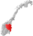
 Innlandet within Norway | |
| Coordinates: 61°30′00″N 10°40′00″E / 61.5°N 10.666667°E | |
| Country | Norway |
| County | Innlandet |
| Established | 1 Jan 2020 |
| Administrative centre | Hamar |
| Area | |
| • Total | 52,072 km2 (20,105 sq mi) |
| • Land | 49,391 km2 (19,070 sq mi) |
| • Water | 2,681 km2 (1,035 sq mi) 5.1% |
| • Rank | 2 in Norway |
| Population (2021) | |
| • Total | 370,603 |
| • Rank | 7 in Norway |
| • Density | 7.5/km2 (19/sq mi) |
| • Change (10 years) | 2.2% |
| Demonym | Innlending[1] |
| Time zone | UTC+01:00 (CET) |
| • Summer (DST) | UTC+02:00 (CEST) |
| ISO 3166 code | NO-34 |
| Official language form | Neutral[2] |
| Preceded by | Oppland and Hedmark |
Innlandet is a county in Norway. It was created on 1 January 2020, by merging the old counties of Oppland and Hedmark. It is in Eastern Norway. Hamar is the biggest city in the county with a population of 28,434.[3]
Farming and forestry are the biggest industries. It helps with 20% of Norway's farming[4] and about 40% of wood.[5]
Etymology: The name means the inland.
Municipalities
[change | change source]Innlandet County has 46 municipalities:[6]
Geography
[change | change source]Mountains
[change | change source]- Galdhøpiggen 2,469 m (8,100 ft)
- Blåkampen 1,662 m (5,453 ft)
- Høgvagltindene 1,576 m (5,171 ft)
- Mjellknapp 1,678 m (5,505 ft)
- Røykeskardhøi 1,808 m (5,932 ft)
- Søndre Svarthåmåren 1,854 m (6,083 ft)
- Søndre Kjølhaugen 1,768 m (5,801 ft)
- Sørhellhøi 1,951 m (6,401 ft)
- Sørhellhøin
- Søverhøi
- Steinahøfjellet 1,711 m (5,614 ft)
- Svånåtindene, mountain range
References
[change | change source]- ↑ "Navn på steder og personer: Innbyggjarnamn" (in Norwegian). Språkrådet.
- ↑ "Forskrift om målvedtak i kommunar og fylkeskommunar" (in Norwegian). Lovdata.no.
- ↑ "Population and land area in urban settlements". Retrieved 9 February 2021.
- ↑ Bondelaget. "Landbruket i Innlandet skaper verdier" (PDF). Retrieved 9 February 2021.
- ↑ Hobbelstad, Kåre. "Ressurssituasjonen i Hedmark of Oppland" (PDF). Retrieved 9 February 2021.
- ↑ List of Norwegian municipality numbers (Norwegian)


 French
 Deutsch

